
- Added SANDERS, ID to cart. View cart.
- Added ERICKSON-KENT RANCH, WY to cart. View cart.
- Added EAST MIDDLEBURY, VT to cart. View cart.
- Added WARNER SPRINGS, CA to cart. View cart.
- Added INDIAN HEAD, MD to cart. View cart.
- Added ARIZONA, AZ to cart. View cart.
- Added DURANGO, CO-NM HISTORICAL MAP GEOPDF 1X2 to cart. View cart.
- Added LACEY, WA to cart. View cart.
- Added MESQUITE, NV-AZ HISTORICAL MAP GEOPDF 7. to cart. View cart.
- Added OSWALD DOME, TN to cart. View cart.
- Added BRANCH MOUNTAIN, CA to cart. View cart.
- Added CONEJO CREEK EAST, NM to cart. View cart.
- Added WELL SPRING, TN to cart. View cart.
- Added ENGLEWOOD, IL to cart. View cart.
- Added CHELBACHEB (ROCK ISLANDS) NORTH, PW HIST to cart. View cart.
- Added BUENA VISTA LAKE BED, CA to cart. View cart.
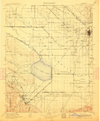

Product Details
- Product Number
- 846085
- Scale
- 1:125,000
- Version Date
- 01/01/1910
- Regions
- CA
- Countries
- USA
- Media
- Paper
- Format
- Flat
- Digital Reproduction
- Yes
Additional Details
- Description
- BUENA VISTA LAKE, CA HISTORICAL MAP GEOPDF 30X30 GRID 125000-SCALE 1910
- Survey Date
- 1910
- Print Date
- 1912
- Boundary Type
- Quadrangle
- Pieces
- 1
Related Items
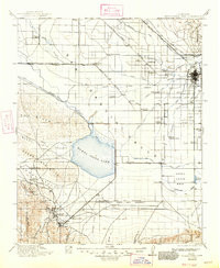
BUENA VISTA LAKE, CA HISTORICAL MAP GEOPDF 30X30 GRID 125000-SCALE 1912

BUENA VISTA LAKE BED, CA HISTORICAL MAP GEOPDF 7.5X7.5 GRID 24000-SCALE 1950
BUENA VISTA LAKE BED, CA HISTORICAL MAP GEOPDF 7.5X7.5 GRID 24000-SCALE 1950