
- Added NOKOMIS, IL HISTORICAL MAP GEOPDF 7.5X7. to cart. View cart.
- Added CLOVERDALE, IN to cart. View cart.
- Added PORTERVILLE, MS-AL HISTORICAL MAP GEOPDF to cart. View cart.
- Added TEMECULA, CA HISTORICAL MAP GEOPDF 7.5X7 to cart. View cart.
- Added TWO ROCK, CA HISTORICAL MAP GEOPDF 7.5X7 to cart. View cart.
- Added EATON, AR to cart. View cart.
- Added TROUT LAKE, WA HISTORICAL MAP GEOPDF 7.5 to cart. View cart.
- Added RURALDALE, OH HISTORICAL MAP GEOPDF 7.5X to cart. View cart.
- Added EPPING, NH to cart. View cart.
- Added SAVORY MOUNTAIN, NV to cart. View cart.
- Added HATTON, AL to cart. View cart.
- Added MYSTERY CAVE, MT-WY to cart. View cart.
- Added WATER RESOURCES OF SABINE PARISH, LA to cart. View cart.
- Added COOLVILLE, OH-WV to cart. View cart.
- Added LITCHFIELD, CT to cart. View cart.
- Added EL PASO, TX to cart. View cart.


Product Details
- Product Number
- 96318
- Scale
- 1:24,000
- Alternate ID
- TTX1231
- ISBN
- 978-0-607-91604-1
- Version Date
- 01/01/1997
- Regions
- CHH, TX
- Countries
- Mexico
- Media
- Paper
- Format
- Flat
- Digital Reproduction
- Yes
Additional Details
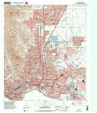
- Description
- EL PASO, TX HISTORICAL MAP GEOPDF 7.5X7.5 GRID 24000-SCALE 1997
- Survey Date
- 1997
- Print Date
- 1999
- Height In Inches
- 27.000
- Length In Inches
- 23.100
- Boundary Type
- Quadrangle
- Two Sided
- No
- Pieces
- 1
- Languages
- English
Related Items
EL PASO, TX HISTORICAL MAP GEOPDF 7.5X7.5 GRID 24000-SCALE 1997
