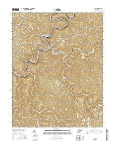
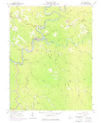
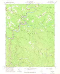
- Added AKRON EAST, OH to cart. View cart.
- Added PARKLAND, WI-MN to cart. View cart.
- Added HALF MOON BAY, CA to cart. View cart.
- Added MISSISSIPPI CREEK, CA to cart. View cart.
- Added OXBOW MOUNTAIN, AZ to cart. View cart.
- Added BLACK BROOK, WI to cart. View cart.
- Added GROVETON WEST, TX to cart. View cart.
- Added MCCLURE, PA to cart. View cart.
- Added PIGEON MOUNTAIN, UT to cart. View cart.
- Added OSHKOSH, WI to cart. View cart.
- Added CHEYENNE, WY to cart. View cart.
- Added GLOBE, CA to cart. View cart.
- Added CINCINNATI, OH-IN-KY HISTORICAL MAP GEOP to cart. View cart.
- Added CARLSBAD CAVERNS EAST, NM-TX HISTORICAL to cart. View cart.
- Added APPLETON, WI to cart. View cart.
- Added RYAN, TX to cart. View cart.
- Added BINGHAM, SC to cart. View cart.
- Added CLAY, WV to cart. View cart.
Product Details
- Product Number
- 293762
- Scale
- 1:24,000
- Version Date
- 01/01/1967
- Regions
- WV
- Countries
- USA
- Media
- Paper
- Format
- Flat
Additional Details
- Description
- CLAY, WV HISTORICAL MAP GEOPDF 7.5X7.5 GRID 24000-SCALE 1967
- Survey Date
- 1967
- Print Date
- 1968
- Height In Inches
- 26.900
- Length In Inches
- 22.000
- Boundary Type
- Quadrangle
- Pieces
- 1
Related Items