
Added FOLD AND THRUST BELT MAP EAST HALF, US to cart. View cart.

Product Details
- Product Number
- 28939
- Scale
- 1:2,500,000
- Alternate ID
- GIA0018-3T
- ISBN
- 978-0-607-85918-8
- Authors
- BAYER, K. C.
- Version Date
- 01/01/1983
- Countries
- USA
- Media
- Paper
- Format
- Flat
- Digital Reproduction
- Yes
Additional Details
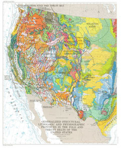
- Description
- 28939 WEST HALF 28938 EAST HALF 28937 LEGEND
- Survey Date
- 1983
- Print Date
- 1984
- Height In Inches
- 51.000
- Length In Inches
- 41.000
- Boundary Type
- Political Unit
- Two Sided
- No
- Pieces
- 1
- Languages
- English
Related Items
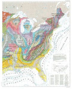
GENERALIZED STRUCTURAL LITHOLOGIC AND PHYSIOGRAPHIC PROVINCES IN THE FOLED AND THRUST BELTS OF THE UNITED STATES: EXCLUSIVE OF ALAKSA AND HAWAII - EAST HALF
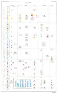
GENERALIZED STRUCTURAL LITHOLOGIC AND PHYSIOGRAPHIC PROVINCES IN THE FOLD AND THRUST BELTS OF THE UNITED STATES: EXCLUSIVE OF ALAKSA AND HAWAII - LEGEND

GRAVITY ANOMALY MAP OF THE UNITED STATES, PART A CONTERMINOUS UNITED STATES, WEST HALF