
- Added WILDWOOD, NJ to cart. View cart.
- Added WEST UNITY, OH HISTORICAL MAP GEOPDF 7.5 to cart. View cart.
- Added LAUREL BLOOMERY, TN-VA to cart. View cart.
- Added ERIE SOUTH, PA to cart. View cart.
- Added RATTLESNAKE BUTTE, MT HISTORICAL MAP GEO to cart. View cart.
- Added ELKINS, AR HISTORICAL MAP GEOPDF 7.5X7.5 to cart. View cart.
- Added YORBA LINDA, CA HISTORICAL MAP GEOPDF 7. to cart. View cart.
- Added GOSHEN, VA to cart. View cart.
- Added MINONK, IL HISTORICAL MAP GEOPDF 7.5X7.5 to cart. View cart.
- Added MOUNT WRIGHTSON, AZ HISTORICAL MAP GEOPD to cart. View cart.
- Added SWAIN MOUNTAIN, CA to cart. View cart.
- Added MILLERSTOWN, PA to cart. View cart.
- Added WEST DIXIE BEND, FL to cart. View cart.
- Added ATWOOD, TN HISTORICAL MAP GEOPDF 7.5X7.5 to cart. View cart.
- Added PORT ARTHUR, LA-TX HISTORICAL MAP GEOPDF to cart. View cart.
- Added RITTMAN, OH HISTORICAL MAP GEOPDF 7.5X7. to cart. View cart.
- Added BOYCEVILLE, WI to cart. View cart.
- Added HARTFORD, AL HISTORICAL MAP GEOPDF 7.5X7 to cart. View cart.
- Added KEZAR FALLS, ME-NH HISTORICAL MAP GEOPDF to cart. View cart.
- Added SACRAMENTO, CA HISTORICAL MAP GEOPDF 30X to cart. View cart.
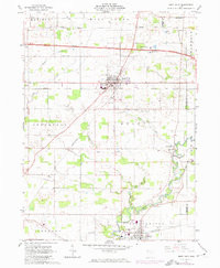
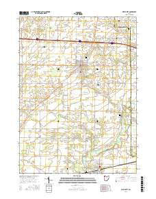
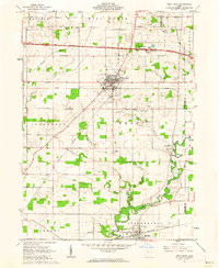
- Added WEST UNITY, OH to cart. View cart.

Product Details
- Product Number
- 86465
- Scale
- 1:24,000
- Alternate ID
- TOH0725
- ISBN
- 978-0-607-42753-0
- Version Date
- 01/01/1973
- Regions
- OH
- Countries
- USA
- Media
- Paper
- Format
- Flat
- Digital Reproduction
- Yes
Additional Details
- Description
- WEST UNITY, OH HISTORICAL MAP GEOPDF 7.5X7.5 GRID 24000-SCALE 1961
- Survey Date
- 1961
- Print Date
- 1974
- Height In Inches
- 26.900
- Length In Inches
- 22.100
- Boundary Type
- Quadrangle
- Two Sided
- No
- Pieces
- 1
- Languages
- English
Related Items

WEST UNITY, OH HISTORICAL MAP GEOPDF 7.5X7.5 GRID 24000-SCALE 1961