- Added RYAN SE, OK to cart. View cart.
- Added MONETA, VA to cart. View cart.
- Added BOTELLA CREEK, TX HISTORICAL MAP GEOPDF to cart. View cart.
- Added SUPERIOR, AZ HISTORICAL MAP GEOPDF 15X15 to cart. View cart.
- Added LAUREL WEST, MS to cart. View cart.
- Added GRANBURY, TX HISTORICAL MAP GEOPDF 7.5X7 to cart. View cart.
- Added DUBUQUE NORTH, WI-IA-IL HISTORICAL MAP G to cart. View cart.
- Added BEAR MOUNTAIN, TX to cart. View cart.
- Added PORT ALEXANDER D-1 SE, AK to cart. View cart.
- Added EASTLAKE, CO to cart. View cart.
- Added ELGIN WEST, TX HISTORICAL MAP GEOPDF 7.5 to cart. View cart.
- Added MOUNT BURWELL, WY to cart. View cart.
- Added PUMICE DESERT EAST, OR to cart. View cart.
- Added WADSWORTH, TX to cart. View cart.
- Added FORT HUACHUCA, AZ to cart. View cart.
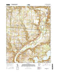
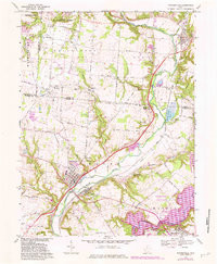
- Added WAYNESVILLE, OH to cart. View cart.

Product Details
- Product Number
- 86449
- Scale
- 1:24,000
- Alternate ID
- TOH0708
- ISBN
- 978-0-607-42739-4
- Version Date
- 01/01/1981
- Regions
- OH
- Countries
- USA
- Media
- Paper
- Format
- Flat
- Digital Reproduction
- Yes
Additional Details
- Description
- WAYNESVILLE, OH HISTORICAL MAP GEOPDF 7.5X7.5 GRID 24000-SCALE 1968
- Survey Date
- 1968
- Print Date
- 1982
- Height In Inches
- 26.900
- Length In Inches
- 22.100
- Boundary Type
- Quadrangle
- Two Sided
- No
- Pieces
- 1
- Languages
- English
Related Items