
- Added PORT JERVIS SOUTH, NY-NJ-PA to cart. View cart.
- Added PINE BUSH, NY to cart. View cart.
- Added DRUMMOND SE, MI to cart. View cart.
- Added GILBERT, WA to cart. View cart.
- Added CULP RANCH, NM to cart. View cart.
- Added CULP DRAW, NM-TX TNM GEOSPATIAL PDF 7.5X to cart. View cart.
- Added CULP CANYON, NM to cart. View cart.
- Added BELLINGHAM NORTH, WA to cart. View cart.
- Added MOODY, TX to cart. View cart.
- Added BASTROP, TX to cart. View cart.
- Added DEVILS HOLE CREEK, WY HISTORICAL MAP GEO to cart. View cart.
- Added ROUSSEAU CREEK SW, SD to cart. View cart.
- Added OSWEGO WEST, NY to cart. View cart.
- Added BOONE DAM, TN to cart. View cart.
- Added OKANOGAN-WENATCHEE NF - LEAVENWORTH, WA to cart. View cart.
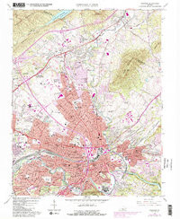
- Added ROANOKE, VA to cart. View cart.


Product Details
- Product Number
- 262405
- Scale
- 1:62,500
- Version Date
- 01/01/1929
- Regions
- VA
- Countries
- USA
- Media
- Paper
- Format
- Flat
Additional Details
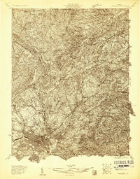
- Description
- ROANOKE, VA HISTORICAL MAP GEOPDF 15X15 GRID 62500-SCALE 1929
- Survey Date
- 1929
- Print Date
- 1961
- Height In Inches
- 20.900
- Length In Inches
- 17.100
- Boundary Type
- Quadrangle
- Pieces
- 1
Related Items
ROANOKE, VA HISTORICAL MAP GEOPDF 15X15 GRID 48000-SCALE 1929
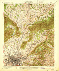
ROANOKE, VA HISTORICAL MAP GEOPDF 15X15 GRID 62500-SCALE 1933