Product

FOCUS AREAS FOR POTENTIAL CRITICAL MINER

$0.00
Available

Product Details

Product Number
534265
Series
FS-2023-3007
Scale
NO SCALE
Alternate ID
FS-2023-3007
Authors
ASSOC AMERICAN STATE GEOLOGIST
Version Date
02/01/2023
Countries
USA
Media
WEB ONLY
Format
WEB ONLY

Additional Details

Description
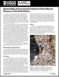
National Map of Focus Areas for Potential Critical Mineral Resources in the United States

Fact Sheet 2023-3007

Prepared in cooperation with the Association of American State Geologists

By: Jane M. Hammarstrom, Douglas C. Kreiner, Connie L. Dicken, and Laurel G. Woodruff

This product is not available for order, it can only be downloaded from here (click on image) or within the Publications Warehouse at https://pubs.er.usgs.gov/publication/fs20233007

For additional information, contact:

Earth Mapping Resources Initiative (Earth MRI)

https://www.usgs.gov/special-topics/earth-mri/

Mineral Resources Program

U.S. Geological Survey

913 National Center

12201 Sunrise Valley Drive

Reston, VA 20192

Email: minerals@usgs.gov

Introduction

The U.S. Geological Survey (USGS) launched the Earth Mapping Resources Initiative (Earth MRI) to modernize the surface and subsurface geologic mapping of the United States, with a focus on identifying areas that may have the potential to contain critical mineral resources. EarthMRI can inform strategies to ensure secure and reliable domestic critical mineral supplies for the United States as mandated by Executive Order 13817 and the Infrastructure and Jobs Act of 2021 (Public Law 117–58, 135 Stat. 529). Earth MRI is a collaborative effort between the USGS and the State geological surveys as represented by the Association of American State Geologists to identify, prioritize, and acquire new geoscience data for geographic areas, or focus areas, across the Nation that have potential to host critical mineral resources. Mapping of focus areas was based on a framework of mineral systems and their associated mineral deposit types that could possibly host critical minerals. Using readily available geologic, geophysical, geochemical, and mineral deposit data, teams of USGS scientists worked with representatives of State geological surveys in a series of workshops to outline focus areas that contain evidence of key features for one or more mineral systems. These areas can be used to guide future efforts to collect new geologic, geophysical, geochemical, and topographic data that focus on critical minerals through Earth MRI.

Survey Date
2023
Print Date
2023
Height In Inches
11.000
Length In Inches
8.500
Languages
English
Related Items
LANDFIRE DATA AND APPLICATIONS
<p> LANDFIRE Data and Applications <p> </p> <font color=red><i> <p> This product is not available for order, it can only be downloaded from here (click on image) or within the Publications Warehouse at https://pubs.er.usgs.gov/publication/fs20223034 </p> </i> </font> <p> <p> First posted May 31, 2022 <p> LANDFIRE help desk Earth Resources Observation and Science Center https://www.usgs.gov/centers/eros U.S. Geological Survey 47914 252nd Street Sioux Falls, SD 57198 <p> <p> Abstract <p> <p> LANDFIRE is a Federal program that provides a suite of spatial datasets indicating areas of disturbance, vegetation and fuels distributions and structure, and historical conditions. The level of detail presented in LANDFIRE’s classifications of disturbance, vegetation, and fuels is unparalleled and can be used in a variety of applications, including (1) modeling wildfire risk and fire behavior, (2) modeling habitat and and species ranges, (3) understanding how disturbances affect the landscape, and (4) researching departure from precolonial conditions. Additionally, the all-lands paradigm of LANDFIRE mapping creates spatial data that do not stop at jurisdictional boundaries. The primary research and management applications of LANDFIRE data are detailed in this fact sheet, providing users with a well-rounded understanding of the potential of LANDFIRE’s spatial data layers. <p>
THE USGS NATIONAL WATER DASHBOARD
<p> Water Priorities for the Nation—The USGS National Water Dashboard <p> </p> <font color=red><i> <p> This product is not available for order, it can only be downloaded from here (click on image) or within the Publications Warehouse at https://pubs.er.usgs.gov/publication/fs20223003 </p> </i> </font> <p> <p> First posted March 2, 2022 <p> For additional information, contact: Associate Director, Water Resources Mission Area https://www.usgs.gov/mission-areas/water-resources U.S. Geological Survey 12201 Sunrise Valley Drive Reston, VA 20192 <p> <p> Abstract <p> <p> The U.S. Geological Survey National Water Dashboard supplies critical information to decision makers, emergency managers, and the public during extreme hydrologic events (such as droughts and floods) and during normal hydrologic conditions. It informs decision making that can help protect lives and property before and during extreme hydrologic events. The National Water Dashboard draws upon the extensive site-specific hydrologic data housed in the U.S. Geological Survey National Water Information System database (https://doi.org/10.5066/F7P55KJN) and also links to the U.S. Geologic Survey WaterAlert system, which provides users with instant and customized updates about water conditions. Overall, the National Water Dashboard is part of the U.S. Geological Survey's effort to respond to 21st century science needs. <p>
Water Priorities for the Nation
<p> Prioridades de la nación referentes al agua— Panel Nacional del Agua del USGS <p> </p> <font color=red><i> <p> This product is not available for order, it can only be downloaded from here (click on image) or within the Publications Warehouse at https://pubs.er.usgs.gov/publication/fs20223003 </p> </i> </font> <p> <p> First posted March 2, 2022 <p> For additional information, contact: Associate Director, Water Resources Mission Area https://www.usgs.gov/mission-areas/water-resources U.S. Geological Survey 12201 Sunrise Valley Drive Reston, VA 20192 <p> <p> Abstract <p> <p> The U.S. Geological Survey National Water Dashboard supplies critical information to decision makers, emergency managers, and the public during extreme hydrologic events (such as droughts and floods) and during normal hydrologic conditions. It informs decision making that can help protect lives and property before and during extreme hydrologic events. The National Water Dashboard draws upon the extensive site-specific hydrologic data housed in the U.S. Geological Survey National Water Information System database (https://doi.org/10.5066/F7P55KJN) and also links to the U.S. Geologic Survey WaterAlert system, which provides users with instant and customized updates about water conditions. Overall, the National Water Dashboard is part of the U.S. Geological Survey's effort to respond to 21st century science needs. <p>