GEOLOGIC MAP OF NW FLANK OF MAUNA LOA

Product Details
- Product Number
- 534086
- Series
- SIM-2932-E
- Scale
- NO SCALE
- Alternate ID
- SIM-2932-E
- ISBN
- 978-1-4113-4471-6
- Authors
- FRANK A TRUSDELL
- Version Date
- 01/01/2022
- Countries
- USA
- Media
- Paper
- Format
- Flat
- Digital Reproduction
- Yes
Additional Details
- Description
-
Geologic Map of the Northwest Flank of Mauna Loa Volcano, Island of Hawai‘i, Hawaii
Scientific Investigations Map 2932-E
By: Frank A. Trusdell and John P. Lockwood
https://doi.org/10.3133/sim2932E
Abstract:
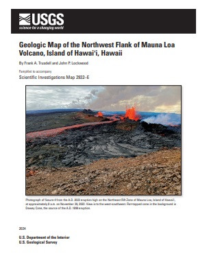
Mauna Loa, the largest active volcano on Earth, has erupted 34 times since written descriptions became available in A.D. 1832. The most recent eruption of Mauna Loa occurred on November 27, 2022, after a 38 year hiatus; it lasted for 12 days. Some eruptions began with only brief seismic unrest, whereas others followed several months to a year of increased seismicity. Once underway, Mauna Loa’s eruptions can produce lava flows that may reach the sea in less than 24 hours, severing roads and utilities. For example, lava flows that erupted from the Southwest Rift Zone in 1950 advanced at an average rate of 9.3 kilometers per hour (5.8 miles per hour); all three lobes reached the ocean within ~24 hours. Near the eruptive vents, the flows likely traveled even faster. In terms of eruption frequency, pre-eruption warning, and rapid flow emplacement, Mauna Loa has great volcanic-hazard potential for the Island of Hawai‘i. Volcanic hazards on Mauna Loa can be anticipated, and risk substantially mitigated, by documenting its past activity to refine our knowledge of the hazards, and by alerting the public and local government officials of our findings and their implications for hazards assessments and risk.
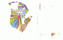
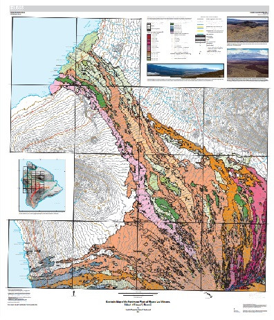
The map of the north and west flanks of Mauna Loa shows the distribution and relation of volcanic and surficial sedimentary deposits. It incorporates previously reported work published as generalized small-scale maps and a more detailed map.
Within the mapped area, lava has flowed from three different source regions: the Northeast Rift Zone (22 percent), the summit (64 percent), and radial vents (14 percent). All three have different points of origin which, in turn, affect the flow characteristics and periodicity of activity.
The map area includes the uppermost part of the NERZ and extends from the highest elevation––13,040 feet at the south end of the Kokoolau quadrangle, just below the summit caldera––to the sea northwest and west of the summit. Lava that erupts from the north and west flanks typically flows to the west, northwest, or north, depending on the vent location. Both morphologic lava flow types—‘a‘a and pahoehoe—are present. Pahoehoe units tend to spread out or widen in low-slope regions, such as in the saddle regions between Mauna Loa and Mauna Kea or between Mauna Loa and Hualalai. In comparison, ?a?a flows generally produce narrower flow lobes that have higher relief.
This map is the fifth in a series of five maps that will cover Mauna Loa volcano.
- Print Date
- 2022
- Two Sided
- No
- Pieces
- 1
- Languages
- English