
ERUPTIVE HISTORY, MAMMOTH MOUNTAIN, CA

Product Details
- Product Number
- 527338
- Series
- PP-1812
- Scale
- NO SCALE
- Alternate ID
- 16-1812
- ISBN
- 978-1-4113-4065-7
- Authors
- JUDY FIERSTEIN
- Version Date
- 01/01/2016
- Regions
- CA
- Countries
- USA
- Media
- Paper
- Format
- Bound
Additional Details
- Description
-
Abstract
First posted July 13, 2016
For additional information, contact:
Contact Information, Volcano Science Center - Menlo Park U.S. Geological Survey 345 Middlefield Road, MS 910 Menlo Park, CA 94025 http://volcanoes.usgs.gov/
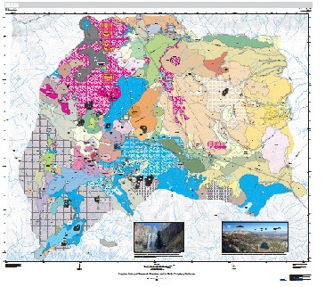
This report and accompanying geologic map portray the eruptive history of Mammoth Mountain and a surrounding array of contemporaneous volcanic units that erupted in its near periphery. The moderately alkaline Mammoth eruptive suite, basaltic to rhyodacitic, represents a discrete new magmatic system, less than 250,000 years old, that followed decline of the subalkaline rhyolitic system active beneath adjacent Long Valley Caldera since 2.2 Ma (Hildreth, 2004). The scattered vent array of the Mammoth system, 10 by 20 km wide, is unrelated to the rangefront fault zone, and its broad nonlinear footprint ignores both Long Valley Caldera and the younger Mono-Inyo rangefront vent alignment.
The Mammoth Lakes area of Mono County, owing to its spectacular alpine landscape, has become one of California’s busiest recreational playgrounds and a regional center of real estate development. The name applies to the town of Mammoth Lakes as well as to the cluster of lakes in a large cirque southwest of town that is now locally called the Lakes Basin. The town has spread around the eastern base of Mammoth Mountain, a late Pleistocene pile of silicic lava domes, and has locally expanded onto lower slopes of the mountain itself (fig. 1). Looming nearly 1,000 m above the downtown area, much of the 5-km-wide volcanic edifice has been laced with chair lifts, gondolas, ski runs, and bike paths by the Mammoth Mountain Ski Area, a corporate entity under permit from Inyo National Forest. In addition to skiing, longestablished, snowboarding and summertime mountain biking have recently become major activities. Tourism to Mammoth Lakes is estimated to be 1,300,000 visitors per winter and 1,500,000 per summer. Some of America’s top long-distance runners also live and train in Mammoth Lakes, attracted by its elevation and its variety of challenging trails.
At the western base of Mammoth Mountain, along the canyon of the Middle Fork San Joaquin River, lies the Devils Postpile National Monument, a National Park Service enclave surrounded by extensive wilderness areas administered by the U.S. Forest Service. As many as 2,000 visitors per day enter the monument during the summer season. The area also contains several of the busiest trailheads in the Sierra Nevada, providing wilderness access for hikers, pack animals, mountaineers, and fishermen.
Many geographic names that appear in this report are informal despite having been in local use for decades. Most appear on maps distributed by the Town of Mammoth Lakes or the Mammoth Mountain Ski Area and can be found here on map figures 2–5, on several photo figures, and on the geologic map.
- Print Date
- 2016
- Height In Inches
- 11.000
- Width In Inches
- 0.210
- Length In Inches
- 8.500
- Two Sided
- Yes
- Pieces
- 1
- Languages
- English
