


COASTAL PLAIN AQUIFER SYSTEM OF VIRGINIA

Product Details
- Product Number
- 424584
- Series
- SIR-2015-5117
- Scale
- NO SCALE
- Alternate ID
- SIR-2015-5117
- ISBN
- 978-1-4113-3970-5
- Authors
- E RANDOLPH MCFARLAND
- Version Date
- 01/01/2015
- Regions
- VA
- Countries
- USA
- Media
- Paper
- Format
- Bound
Additional Details
- Description
-
Abstract
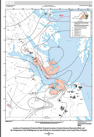
A conceptual framework synthesizes previous studies to provide an understanding of conditions, processes, and relations of saltwater to groundwater withdrawal in the Virginia Coastal Plain aquifer system. A strategy for monitoring saltwater movement is based on spatial relations between the saltwater-transition zone and 612 groundwater-production wells that were regulated during 2013 by the Virginia Department of Environmental Quality. The vertical position and lateral distance and direction of the bottom of each production well’s screened interval was calculated relative to previously published groundwater chloride iso-concentration surfaces. Spatial analysis identified 81 production wells completed in the Yorktown-Eastover and Potomac aquifers that are positioned in closest proximity to the 250-milligrams-per-liter chloride surface, and from which chloride concentrations are most likely to increase above the U.S. Environmental Protection Agency’s 250-milligrams-per-liter secondary maximum-contaminant level. Observation wells are specified to distinguish vertical upconing from lateral intrusion among individual production wells. To monitor upconing, an observation well is to be collocated with each production well and completed at about the altitude of the 250-milligrams-per-liter chloride iso-concentration surface. To monitor lateral intrusion, a potential location of an observation well is projected from the bottom of each production well’s screened interval, in the lateral direction to the underlying chloride surface to a distance of 1 mile.
Monitoring potential withdrawal-induced movement of saltwater in the Virginia Coastal Plain aquifer system is needed to detect increases in chloride concentration before groundwater-production wells become contaminated. An investigation was undertaken during 2014 by the U.S. Geological Survey in cooperation with the Virginia Department of Environmental Quality, to provide a sound scientific understanding of saltwater movement and guidance to implement a monitoring program. Previous studies have theorized that the saltwater originated primarily from seawater repeatedly emplaced within aquifer sediments during the past about 65 million years. Subsequent flushing by fresh groundwater has been impeded across sediments filling the Chesapeake Bay impact crater. The resulting saltwater-transition zone has been mapped to exhibit a warped and steeply mounded dome shape about centered on the impact crater, and flanked by a nearly level and shallow plateau shape to the southeast. Groundwater chloride concentrations have historically fluctuated during periods of weeks to months, probably as a result of localized vertical upconing beneath individual production wells. Lateral intrusion takes several decades or more to horizontally displace groundwater across distances of about 1 mile toward production wells. Upconing is relatively immediate, but reversible, whereas lateral intrusion under the regionally landward hydraulic gradient may slowly, but permanently reposition the saltwater-transition zone. Upconing coupled with lateral intrusion is theorized to produce composite chloride-concentration trends that vary widely over time in response to changing water demands, and evolve dynamically from hydraulic interactions among multiple neighboring production wells.
Some aspects of observation-well construction and sampling are of particular importance to monitoring saltwater movement in the Virginia Coastal Plain aquifer system. Observation wells should feature screened intervals generally of no more than 10 feet that isolate distinct parts of the aquifer, and be thoroughly developed for removal of drilling fluid and introduced water. Presample purging should fully displace stratified saltwater in the well casing upward to the pump. Stable flow should be maintained as field parameters are measured and sample containers are filled with filtered water isolated from the atmosphere and unaffected by surface temperature. Groundwater samples from both upconing and lateral-intrusion observation wells should initially be collected four times per year when wells are newly established, but can be more optimally timed with withdrawal once responses in chloride concentrations can be reliably predicted. Concentrations of major ions (1) determine the dominant chemical composition of groundwater at each well, (2) establish the relative position of the well within the saltwater-transition zone, and (3) provide data quality control by calculation of sample charge balance. For these reasons, samples initially collected for the first year from newly established observation wells should be analyzed for calcium, magnesium, sodium, and potassium cations and chloride, bicarbonate, carbonate, sulfate, fluoride, and bromide anions. Inflection-point titration for alkalinity should be completed in the field. Analysis of chloride and field parameters may be adequate on a long-term basis once the dominant chemical composition at each well is established. Specific conductance may also provide a surrogate for chloride concentration depending on regulatory policy.
The saltwater-movement monitoring strategy is limited and constrained. Relative monitoring needs among groundwater-production wells, and construction of observation wells, depend on the accuracy of previously mapped groundwater chloride iso-concentration surfaces. Production wells in similar proximity to saltwater can differ in aquifer hydraulic conductivity, rates of withdrawal, and screened-interval lengths. Only production wells making withdrawals reported to the Virginia Department of Environmental Quality have been accounted for; undocumented production wells can result in spurious changes in groundwater chloride concentration. Upconing observation wells should be as close as possible to corresponding production wells, so long as production wells are not damaged by borehole deviation. Projected locations of some lateral-intrusion observation wells may be precluded and require adjustment. Depths of upconing and lateral-intrusion observation wells may also require adjustment to be within the same aquifer as their corresponding production wells. Existing unused wells can be adapted as observation wells if differences from specified locations and construction are kept to a minimum and are accounted for. Where multiple production wells are in proximity, a modified monitoring approach may be needed to determine their net effect on changes in chloride concentration, and may require more than one lateral-intrusion observation well depending on the vertical positions of production-well screened intervals.
- Survey Date
- 2015
- Print Date
- 2015
- Height In Inches
- 11.000
- Length In Inches
- 8.500
- Two Sided
- Yes
- Pieces
- 3
- Languages
- English

