
GEOLOGIC MAP OF THE EASTERN HALF VAIL CO
$9.00
Available

Product Details
- Product Number
- 317990
- Series
- SIM-3170
- Scale
- 1:50,000
- Alternate ID
- SIM3170
- ISBN
- 978-1-4113-3184-6
- Authors
- BRUCE BRYANT
- Version Date
- 01/01/2011
- Regions
- CO
- Countries
- USA
- Media
- Paper
- Format
- Folded
Additional Details
- Description
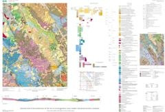
- Abstract Recent mapping and geochronologic studies for the eastern half of the Vail 1:100,000-scale quadrangle have significantly improved our understanding of (1) Paleoproterozoic history of the basement rocks of the Gore Range and Williams Fork Mountains (western margin of the Front Range), (2) the Late Paleozoic history of the Gore fault system, (3) Laramide contractional tectonism, including deformation along the Gore fault and Williams Range thrust, (4) Oligocene and younger extensional history of the Blue River half graben (The northern extent of the Rio Grande rift), and (5) late Neogene and Quaternary surficial history. The recently active Gilman mining district, a major producer of zinc and lead, is in the southwestern corner of the map area. Marine sediments and mafic to felsic volcanic rocks deposited between about 1,740 and 1 ,780 m.y. were generally metamorphosed to amphibolite grade and intruded and deformed by mostly calc-alkalic granitic rocks during an orogenic episode that lasted about 110 m.y. The distribution of well-studied Upper Cambrian to thick Upper Cretaceous platform sediments is now greatly improved, which allows a better definition of the late Paleozoic uplift, erosion, and flanking sedimentation of the ancestral Front Range. Detailed mapping has also better defined the geometry of Late Cretaceous to early Tertiary Laramide deformation along both the Gore fault system and Williams Range thrust, as well as increased understanding of the details of mostly Neogene extension along the Blue River normal fault system (the western margin of the Blue River half gr aben). Scarps along the latter fault system indicate movement may be as young as Holocene. Detailed mapping of surficial deposits has defined and described (1) six ages of terrace alluvium, (2) three general ages of landslides, (3) glacial and periglacial deposits, and (4) fan, pediment, talus, and debris-flow deposits. The map is intended as a database for a variety of land-use and scientific purposes, including (1) assessment of geologically stable building sites, (2) planning for road and highway construction, (3) assessment of groundwater resources, (4) assessment of mineral resources, (5) determining geologic-hazard potential (flooding, landslide, rockfall, and seismic risk), (6) evaluating the structure of the northern Rio Grande rift in the Blue River valley, (7) improvement in understanding of the sedimentary section, which spans the period from the Cambrian to the Holocene, and (8) new insights into the geologic history of the Proterozoic basement rocks, including a number of new radiometric dates.
- Survey Date
- 2011
- Print Date
- 2011
- Height In Inches
- 32.000
- Length In Inches
- 45.000
- Boundary Type
- Quadrangle
- Two Sided
- No
- Pieces
- 2
- Languages
- English
Related Items


Geologic Map of the Vail East Quadrangle, Eagle County, Colorado

Geologic Map of the Dillon quadrangle, Summit and Grand Counties, Colorado