
AEROMAGNETIC LATIR WHEELER PK, NM

Product Details
- Product Number
- 30997
- Series
- MF-1570-C
- Scale
- 1:50,000
- Alternate ID
- GMF1570CD
- ISBN
- 978-0-607-81322-7
- Authors
- ABRAMS, G. A.
- Version Date
- 01/01/1985
- Regions
- NM
- Countries
- USA
- Media
- Paper
- Format
- Flat
- Digital Reproduction
- Yes
Additional Details
- Description
-
Abstract
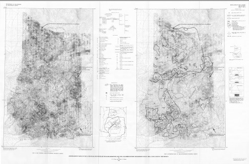
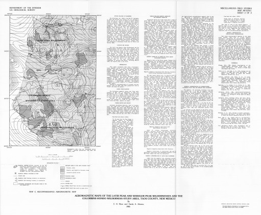
This report interprets data from a helicopter-borne magnetic survey to help delineate subsurface geology. Such data, acquired near the ground, reflect greater magnetic detail than do data acquired at higher altitude. Data from a high-altitude reconnaissance aeromagnetic survey (U.S. Geological Survey, 1976) are used selectively to assist in the interpretation of the helicopter data.
Interpretations are chiefly empirical, wherein magnetic anomalies characterizing known geologic features in the region are used as interpretive criteria for identifying such features where they are concealed. Identifying geologic environments favorable for mineral deposits is a primary objective of this report.
Geophysical interpretations of a broader and more general scope are made from other geophysical data by Cordell and Jones (in press).
- Survey Date
- 1985
- Print Date
- 1985
- Height In Inches
- 38.740
- Length In Inches
- 58.650
- Boundary Type
- Quadrangle
- Two Sided
- No
- Pieces
- 1
- Languages
- English
