
Product Details
- Product Number
- 296887
- Series
- OFR-2008-1221
- Scale
- NO SCALE
- Alternate ID
- 081221
- Authors
- MICHAEL C HANSEN
- Version Date
- 01/01/2008
- Regions
- OH
- Countries
- USA
- Media
- Paper
- Format
- Flat
- Digital Reproduction
- Yes
Additional Details
- Description
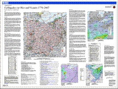
- Introduction This map summarizes two and a third centuries of earthquake activity. The seismic history consists of letters, journals, diaries, and newspaper and scholarly articles that supplement seismograph recordings (seismograms) dating from the early twentieth century to the present. All of the pre-instrumental (historical) earthquakes were large enough to be felt by people or to cause shaking damage to buildings and their contents. Later, widespread use of seismographs meant that tremors too small or distant to be felt could be detected and accurately located. Earthquakes are a legitimate concern in Ohio and parts of adjacent States. Ohio has experienced more than 160 felt earthquakes since 1776. Most of these events caused no damage or injuries. However, 15 Ohio earthquakes resulted in property damage and some minor injuries. The largest historic earthquake in the state occurred in 1937. This event had an estimated magnitude of 5.4 and caused considerable damage in the town of Anna and in several other western Ohio communities. The large map shows all historical and instrumentally located earthquakes from 1776 through 2007.
- Height In Inches
- 36.000
- Length In Inches
- 48.000
- Two Sided
- No
- Pieces
- 1
- Languages
- English
Related Items