


Product Details
- Product Number
- 28331
- Series
- I-2152
- Scale
- NO SCALE
- Alternate ID
- GI2152D
- ISBN
- 978-0-607-79322-2
- Authors
- HETTINGER, R. D.
- Version Date
- 01/01/1991
- Regions
- WY
- Countries
- USA
- Media
- Paper
- Format
- Folded
Additional Details
- Description
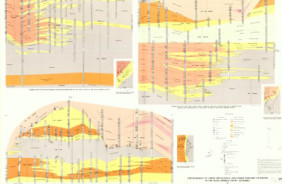
- Chart showing correlations of some upper Cretaceous and lower Tertiary rocks, from the east flank of the Washakie Basin to the east flank of the Rock Springs Uplift, Wyoming
- Survey Date
- 1991
- Print Date
- 1991
- Boundary Type
- Quadrangle
- Two Sided
- No
- Pieces
- 1
- Languages
- English
Related Items
Chart showing correlations of upper Cretaceous Fox Hills Sandstone and Lance Formation, and lower Tertiary Fort Union, Wasatch, and Green River formations, from the eastern flank of the Washakie Basin to the southeastern part of the Great Divide Basin, Wyoming
Stratigraphy of Upper Cretaceous and Lower Tertiary outcrops in the Rock Springs Uplift, Wyoming
Preliminary Chart Showing Electric Log Correlation Section G-G' of some Upper Cretaceous and Tertiary Rocks, East Flank, Rock Springs Uplift, Washakie Basin, Wyoming 3 oversized sheets