


Product Details
- Product Number
- 24596
- Series
- GQ-1517
- Scale
- 1:24,000
- Alternate ID
- GGQ1517D
- ISBN
- 978-0-607-75545-9
- Authors
- SCHMITT, LEONARD J.
- Version Date
- 01/01/1979
- Regions
- WY
- Countries
- USA
- Media
- Paper
- Format
- Folded
Additional Details
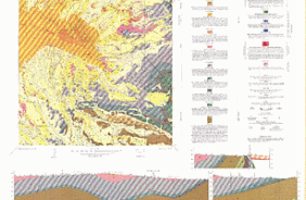
- Description
- Geologic map of the Crooks Peak quadrangle, Fremont and Sweetwater Counties, Wyoming
- Survey Date
- 1974
- Print Date
- 1979
- Boundary Type
- Quadrangle
- Two Sided
- No
- Pieces
- 1
- Languages
- English
Related Items
Geologic map of the Whiskey Peak quadrangle, Carbon, Fremont and Sweetwater counties, Wyoming
Geologic map of the Bairoil quadrangle, Sweetwater and Carbon Counties, Wyoming
Geologic map of the Sagebrush Park quadrangle, Fremont and Sweetwater Counties, Wyoming