

Product Details
- Product Number
- 24226
- Series
- GQ-1145
- Scale
- 1:62,500
- Alternate ID
- GGQ1145D
- ISBN
- 978-0-607-75173-4
- Authors
- BERGIN, M. J.
- Version Date
- 01/01/1974
- Regions
- CO
- Countries
- USA
- Media
- Paper
- Format
- Flat
- Digital Reproduction
- Yes
Additional Details
- Description
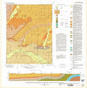
- Geologic map of the Maybell quadrangle, Moffat County, Colorado
- Survey Date
- 1974
- Print Date
- 1974
- Height In Inches
- 25.820
- Length In Inches
- 25.440
- Boundary Type
- Quadrangle
- Two Sided
- No
- Pieces
- 1
- Languages
- English
Related Items

Geologic map of the Chicken Creek SW quadrangle, Sweetwater County, Wyoming and Moffat County, Colorado
Geologic map of the Indian Water Canyon quadrangle, Moffat County, Colorado
Geologic map of the Plug Hat Rock quadrangle, Moffat County, Colorado