


Product Details
- Product Number
- 209151
- Series
- SIM-3085
- Scale
- 1:5,000,000
- Alternate ID
- SIM3085
- Authors
- PATRICK COMER
- Version Date
- 01/01/2009
- Countries
- USA
- Media
- Paper
- Format
- Flat
- Digital Reproduction
- Yes
Additional Details
- Description
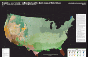
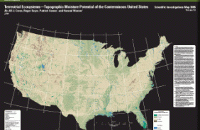
- As part of an effort to map terrestrial ecosystems, the U.S. Geological Survey has generated land surface form classes to be used in creating maps depicting standardized, terrestrial ecosystem models for the conterminous United States, using an ecosystems classification developed by NatureServe . A biophysical stratification approach, developed for South America and now being implemented globally, was used to model the ecosystem distributions. Since land surface forms strongly influence the differentiation and distribution of terrestrial ecosystems, they are one of the key input layers in this biophysical stratification. After extensive investigation into various land surface form mapping methodologies, the decision was made to use the methodology developed by the Missouri Resource Assessment Partnership (MoRAP). MoRAP made modifications to Hammond's land surface form classification, which allowed the use of 30-meter source data and a 1-km2 window for analyzing the data cell and its surrounding cells (neighborhood analysis). While Hammond's methodology was based on three topographic variables, slope, local relief, and profile type, MoRAP's methodology uses only slope and local relief. Using the MoRAP method, slope is classified as gently sloping when more than 50 percent of the area in a 1-km2 neighborhood has slope less than 8 percent, otherwise the area is considered moderately sloping. Local relief, which is the difference between the maximum and minimum elevation in a neighborhood, is classified into five groups: 0#15 m, 16#30 m, 31#90 m, 91#150 m, and >150 m. The land surface form classes are derived by combining slope and local relief to create eight landform classes: flat plains (gently sloping and local relief = 15 m), smooth plains (gently sloping and 15 m < local relief = 30 m), irregular plains (gently sloping and 30 m < local relief = 90 m), escarpments (gently sloping and local relief > 90 m), low hills (not gently sloping and local relief = 30 m), hills (not gently sloping and 30 m < local relief = 90 m), breaks/foothills (not gently sloping and 90 m < local relief = 150 m), and low mountains (not gently sloping and local relief > 150 m). However, in the USGS application of the MoRAP methodology, an additional local relief group was used (> 400 m) to capture additional local topographic variation. As a result, low mountains were redefined as not gently sloping and 151 m < local relief < 400 m, and a new land surface form class, high mountains/deep canyons, was identified as not gently sloping and local relief > 400 m. The final application of the MoRAP methodology was implemented using the USGS 30-meter National Elevation Dataset and an existing USGS slope dataset that had been derived by calculating the slope from the NED in Universal Transverse Mercator (UTM) coordinates in each UTM zone, and then combining all of the zones into a national dataset. This map shows a smoothed image of the nine land surface form classes based on MoRAP's methodology. Additional information about this map and any data developed for the ecosystems modeling of the conterminous United States is available online at http:/ /rmgsc.cr.usgs.gov/ecosystems/.
- Height In Inches
- 35.000
- Length In Inches
- 45.000
- Boundary Type
- Quadrangle
- Two Sided
- No
- Pieces
- 1
- Languages
- English
Related Items
Terrestrial Ecosystems#Isobioclimates of the Conterminous United States
Terrestrial Ecosystems#Topographic Moisture Potential of the Conterminous United States
