

Product Details
- Product Number
- 208492
- Series
- SIM-2980
- Scale
- 1:24,000
- Alternate ID
- SIM2980
- ISBN
- 978-1-4113-1913-4
- Authors
- DAVID WEARY J
- Version Date
- 01/01/2008
- Regions
- MO
- Countries
- USA
- Media
- Paper
- Format
- Flat
- Digital Reproduction
- Yes
Additional Details
- Description
-
Abstract
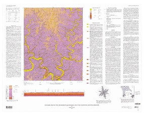
The Cedargrove 7.5-minute quadrangle is located in south-central Missouri within the Salem Plateau region of the Ozark Plateaus physiographic province. Most of the land in the quadrangle is privately owned and used primarily for grazing cattle and horses and growing timber. The map area has topographic relief of about 565 feet (ft), with elevations ranging from about 760 ft at Akers Ferry on the central-southern edge of the map to about 1,325 ft near the town of Jadwin in the north-central part of the map area. The most prominent physiographic features in the quadrangle are the valleys of the Current River and Big Creek in the southwestern part of the map area, and the valley of Gladden Creek, which transects the eastern part of the quadrangle from north to south.
- Survey Date
- 1951
- Print Date
- 2008
- Height In Inches
- 34.000
- Length In Inches
- 42.000
- Boundary Type
- Quadrangle
- Two Sided
- No
- Pieces
- 1
- Languages
- English
