
GEOLOGIC MAP HELLAS PLANITIA REGION MARS

Product Details
- Product Number
- 116707
- Series
- SIM-3096
- Scale
- 1:1,000,000
- Alternate ID
- SIM3096
- ISBN
- 978-1-4113-2631-6
- Authors
- D A CROWN
- Version Date
- 01/01/2010
Additional Details
- Description
-
Abstract
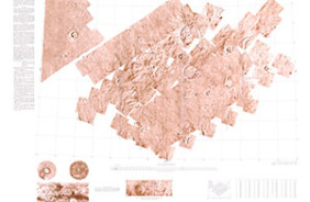
Hellas Planitia comprises the floor deposits of the Hellas basin, more than 2,000 km across and 8 km deep, which is located in the southern hemisphere's cratered highlands and is the largest well-preserved impact structure on the Martian surface. The circum-Hellas highlands represent a significant percentage of the southern hemisphere of Mars and have served as a locus for volcanic and sedimentary activity throughout Martian geologic time. Hellas basin topography has had a long-lasting influence, acting as Mars' deepest and second largest depositional sink, as a source for global dust storms, and as a forcing agent on southern hemisphere atmospheric circulation. The region lies in the Martian mid-latitude zone where geomorphic indicators of past, and possibly contemporary, ground ice are prominent. The highlands north of the basin show concentrations of Noachian valley networks, and those to the east show prominent lobate debris aprons that are considered to be geomorphic indicators of ground ice. Several studies have proposed that Hellas itself was the site of extensive glacial and lacustrine activity. Recent analyses of mineralogical information from Mars Express' OMEGA (Observatoire pour la Mineralogie, l'Eau les Glaces et l'Activite) and Mars Reconnaissance Orbiter's CRISM (Compact Reconnaissance Imaging Spectrometer for Mars) reveal outcrops of hydrated phyllosilicates in the region, strengthening an already strong case for past aqueous activity in and around Hellas basin. Our mapping and evaluation of landforms and materials of the Hellas region from basin rim to floor provides further insight into Martian global climate regimes and into the abundance, distribution, and flux of volatiles through history. Mars Transverse Mercator (MTM) quadrangles -40277, -45277, -45272, and -40272 (lat 37.5 degrees S.-47.5 degrees S., long 270 degrees W.-280 degrees W.) cover the eastern portion of the Hellas basin including the boundary between its floor and rim, the distal portions of Dao and Harmakhis Valles, and the deposits of eastern Hellas Planitia. The geologic mapping, at 1:1,000,000-scale from Viking Orbiter, Thermal Emission Imaging System (THEMIS) infrared (IR) and visible (VIS) wavelength, and Mars Orbiter Camera (MOC) narrow-angle images, combined with Mars Orbiter Laser Altimeter (MOLA) topographic data, characterizes the geologic materials and processes that have shaped this region. In particular, the mapping helps to evaluate landforms and deposits resulting from modification of highland terrains by volatile-driven degradation. This mapping study builds on previous mapping in Hellas Planitia and to the east and facilitates comparisons between the geologic history of the east rim, the remainder of the rim, and Hellas Planitia. Specific objectives of our mapping are (1) to reconstruct fluvial systems that dissect the Hellas rim, (2) to characterize the extensions of Dao and Harmakhis Valles onto the basin floor and to identify, if present, sediments these canyons contributed to Hellas Planitia from the rim, and (3) to investigate the mode of origin, age, and history of modification of the boundary between the east rim and Hellas Planitia.
- Height In Inches
- 49.000
- Length In Inches
- 29.000