

Product Details
- Product Number
- 116047
- Series
- SIM-2820
- Scale
- 1:250,000
- Alternate ID
- SIM2820
- ISBN
- 978-0-607-97553-6
- Authors
- GLENN R SCOTT
- Version Date
- 01/01/2004
- Regions
- CO
- Countries
- USA
- Media
- Paper
- Format
- Folded
Additional Details
- Description
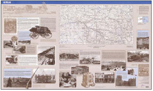
- The Historic Trail Map of the Leadville 1 x 2 Degree Quadrangle is the eleventh map in a series of historic maps published by Glen Scott in collaboration between the Denver Public Library, Western History and Genealogy Department, and the Colorado Railroad Museum. The map depicts Indian trails that were accessible only by foot or horseback which over the years became roads that were used by Conestoga wagons and stagecoaches, and even hand carts such as those used by the Mormons during their immigration to Utah. Included with the Leadville map is a 90-page booklet containing the history of Leadville, along with references to the pictures and trails used on the map. The scale of the map is 1:250,000 with 200-foot contour interval and the measurement of the map is approximately 40 x 56 inches. To view the Historic Trail Map of Denver (Item #28820) and Trinidad (Item #112612) visit our Geology Publications website at: http//cpg.cr.usgs.gov/pub/i-maps.html. To view &/or download a version go to-> http://pubs.usgs.gov/sim/2004/2820
- Survey Date
- 1957
- Print Date
- 2004
- Boundary Type
- Quadrangle
- Two Sided
- No
- Pieces
- 2
- Languages
- English
Related Items

Historic trail map of the Denver 1 degree by 2 degrees Quadrangle, central Colorado

Historic trail map of the Greeley 1 degree by 2 degrees Quadrangle, Colorado and Wyoming
