


Product Details
- Product Number
- 115243
- Series
- WRI-03-4141
- Scale
- NO SCALE
- Alternate ID
- WRIR034141
- Authors
- ANDREW J. STEVENSON
- Version Date
- 01/01/2003
- Regions
- AK
- Countries
- USA
- Media
- Paper
- Format
- Flat
Additional Details
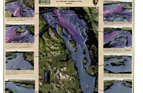
- Description
- Multibeam Bathymetry and Selected Perspective Views of Glacier Bay, Alaska. Glacier Bay is the deepest silled fjord in Alaska with depths over 450 meters has the distinction of having the fasting retreating glacier ever recorded. As a result, some of the highest rates of glacial sedimentation and uplift have occurred here. High-resolution multibeam mapping of the bay, funded jointly by the USGS and National Park Service, provides an unprecedented new baseline for resource and habitat assessment, as well as geological and oceanographic research. This colorful 2-sheet poster illustrates the retreat of the glacier from 1760 to present day. Sheet one (product number 115243) measures 29 by 44 inches and sheet two (product number 115244) measures 33.5 by 31.5 inches. Map scale is 1:50 ,000. For more information, please visit: http://geopubs.wr.usgs.gov/open-file/of02-391 and http://geopubs.wr.usgs.gov/open-file/of02-391/gb-data.html
- Survey Date
- 2003
- Print Date
- 2003
- Two Sided
- No
Related Items
GLACIER BAY NATIONAL PARK,MULTIBEAM BATHYMETRY AND SELECTED PERSPECTIVE VIEWS OF GLACIER BAY, ALASKA SHEET 2 OF 2

Bathymetry and selected perspective views of Crater Lake, Oregon

BATHYMETRY AND SELECTED PERSPECTIVE VIEWS OF CENTRAL SAN FRANCISCO BAY CALIFORNIA (SHEET 2 OF 2)