
GREEN BAY, LOWER, SHORELINE VR, WI

Temporal variability of shoreline positions and coastal wetlands along lower Green Bay, Oconto and Brown counties, Wisconsin
TYONEK B-4, SURF GEOL MAP OF, AK
Surficial geologic map of the Tyonek B-4 Quadrangle, south-central Alaska
GEOPHYS DATA VICINITY OF NEW MADRID, MO
Map showing large structures interpreted from geophysical data in the vicinity of New Madrid
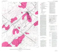
KRUMBO RESERVOIR, GEOL MAP OF, OR
Geologic map of the Krumbo Reservoir Quadrangle, Harney County, Southeastern Oregon
NEW MADRID - GEOPHYSICAL SURV, MO
Map showing locations of geophysical survey and modeling lines in the vicinity of New Madrid, Missouri
EOLIA GEOLOGIC MAP, MO
Geologic map of the Eolia 7.5-minute Quadrangle, Lincoln and Pike counties, Missouri
MAPS AND DIAGRAMS ACOUSTIC, MA
Maps and diagrams showing acoustic and textural characteristics and distribution of bottom sedimentary environments, Boston Harbor and Massachusetts Bay
UPPER MS EMBAYMENT/PALOEZ-GEO, MS
Maps of upper Mississippi embayment Paleozoic and Precambrian rocks
VALENTINES GEOLOGIC MAP, VA
Geologic map of the Valentines 7.5-minute Quadrangle, Brunswick and Greensville counties, Virginia, and Northhampton and Halifax counties, North Carolina
TAR SPRING RIDGE-GEOLOGIC MAP, CA
Geologic map of the Tar Spring Ridge Quadrangle, San Luis Obispo County, California
DOE MOUNTAIN-GEOLOGIC MAP, WA
Geologic map of the Doe Mountain 15' Quadrangle, Okanogan County, Washington
TOLEDO AREA-BEDROCK-SURFACE, OH
Map showing bedrock-surface topography of the Toledo area, northwestern Ohio and southeastern Michigan
YUCCA MOUNTAIN, NYE COUNTY, NV, NV
Logs and Paleoseismic interpretations from Trenches 14C and 14D on the Bow Ridge fault, northeastern Yucca Mountain, Nye County, Nevada
BOX CANYON COULEE & SAND BUTTE, MT
Photogeologic and reconnaissance geologic map of the Box Canyon Coulee and Sand Buttes quadrangles, Rosebud County, Montana
KETCHIKAN/PRINCE RUPERT-GEOLOG, AK
Geologic map of the Craig, Dixon Entrance, and parts of the Ketchikan and Prince Rupert quadrangles, southeastern Alaska