
POWDER RIVER BASIN &, GEOLOGIC, WY

Geologic map of the Powder River Basin and surrounding area, Wyoming, Montana, South Dakota, North Dakota, and Nebraska
AFRICA, W'RN COAST, W SAHARA,
Map showing free-air gravity anomalies off the western coast of Africa Western Sahara to Senegal (north of 15 north latitude)
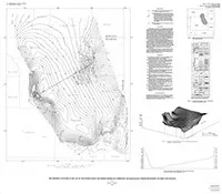
RIDGWAY, RECONN GEOL MAP OF, CO
Reconnaissance geologic map of the Ridgway Quadrangle, Ouray County, Colorado
FREE-AIR GRAVITY ANOMALY CANARY ISLANDS
Map showing free-air gravity anomalies around the Canary Islands, Spain
PARKFIELD, SAN ANDREAS FAULT,, CA
Geologic map of the San Andreas Fault in the Parkfield 7.5-minute Quadrangle, Monterey and Fresno counties, California
GEOLOGIC MAP AVAWATZ MOUNTAINS, CA
Geologic map of southern Avawatz Mountains, northeastern Mojave Desert region, San Bernardino County, California
JOPLIN, STRUCTURE-CONTOUR MAPS, KS
Structure-contour maps on the top of the Mississippian carbonates and on top of the upper Cambrian and lower Ordovician Arbuckle Group, Joplin 1 degree by 2 degrees Quadrangle, Kansas and Missouri
TEXAS CREEK, GEOL MAP OF, CO
Geologic map of the Texas Creek Quadrangle, Rio Blanco County, Colorado
RICHFIELD, THORIUM IN STR SEDI, UT
Map showing distribution of thorium in stream-sediment samples, Richfield 1 degree by 2 degrees Quadrangle, Utah
RICHFIELD, TIN IN STR SEDIMENT, UT
Map showing distribution of tin in stream-sediment samples, Richfield 1 degree by 2 degrees Quadrangle, Utah
POWDER RIVER BASIN,CONT PA-PER, WY
Map showing contours on the top of the Pennsylvanian and Permian Minnelusa Formation and equivalents, Powder River basin, Wyoming and Montana
CHANDLER LAKE, N'RN,GEOCHEM OF, AK
Geochemistry of sediment samples from the northern part of the Chandler Lake Quadrangle, Alaska
HIGH ROCK LAKE, GEOL MAP OF, NV
Geologic map of the High Rock Lake Quadrangle, Washoe and Humboldt counties, Nevada
ELKHORN PEAK, RECON GEOL MAP, ID
Reconnaissance geologic map of Elkhorn Peak Quadrangle, Bannock and Oneida counties, Idaho
TWIN PEAKS AND BLANCA PK, GEOL, CO
Reconnaissance geologic map of parts of the Twin Peaks and Blanca Peak quadrangles, Alamosa, Costilla, and Huerfano counties, Colorado