
GEOLOGY AND ZINC LEAD DURANGO AREA, IA
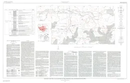
Geology and zinc-lead deposits in the Durango area, Dubuque County, Iowa
LARAMIE RANGE-ANTHROSITE AREAS, WY
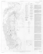
Geologic map of anorthosite areas, southern part of Laramie Range, Wyoming
PIOCHE HILLS, NV

Geologic map and sections of the Pioche Hills, Lincoln County, Nevada
MOUNT PEALE 2 NW, UT
and section of the Mount Peale 2 NW quadrangle, San Juan County, Utah
CLUB MESA AREA-EXPLOR URANIUM, CO
Exploration for uranium-vanadium deposits by the U.S. Geological Survey in the Club Mesa area, Uravan district, Montrose County, Colorado
MOUNT PEALE 3 SE, UT
Mount Peale 3 SE quadrangle, San Juan County, Utah
DEER LODGE-RECONN GEOLOGIC, MT
Reconnaissance geologic map of the Deer Lodge quadrangle, Powell, Deer Lodge, and Jefferson Counties, Montana
EMMET WASH NW, AZ
Emmett Wash NW quadrangle, Coconino County, Arizona
NOME D-1, AK
Preliminary geologic map of the Nome D-1 quadrangle, Seward Peninsula, Alaska
IONE - CENOZOIC GEOLOGY, NV
Cenozoic geology and sections of the Ione quadrangle, Nye County, Nevada
COONEY RESERVOIR, MT
Geologic map of the Cooney Reservoir quadrangle, Carbon and Stillwater Counties, Montana
ROBERTS, MT
Geologic map of the Roberts quadrangle, Carbon County, Montana
THOMPSON PEAK, ID
Geologic map of the Thompson Peak quadrangle, Bonneville County, Idaho
CONANT VALLEY, ID
Geology of the Conant Valley quadrangle, Bonneville County, Idaho
HUSUM, WA
Geologic map of the Husum quadrangle, Washington