
BEDROCK GEOLOGIC MAP SAXTONS RIVER, VT

Bedrock geologic map of the Saxtons River 7.5' by 15' quadrangle, Windham and Windsor counties, Vermont
PLATTE RIVER DRAINAGE BASIN, CO (FOLDED)
Pleistocene glaciation in the upper Platte River drainage basin, Colorado- Folded Version
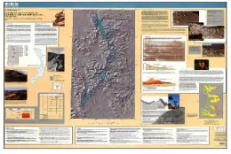
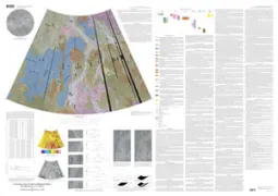
GEOLOGIC SAPPHO PATERA QUAD (V20) VENUS
Geologic map of the Sappho Patera Quadrangle (V-20), Venus
SHADED RELIEF SANTA MONICA MARGIN, CA
Shaded-relief bathymetric and backscatter maps of Santa Monica Margin, California
REPUBLIC OF ARMENIA & SURROUNDING AREAS
REPUBLIC OF ARMENIA AND SURROUNDING AREAS
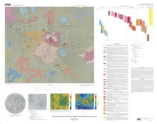
GEOLOGIC MAP GUSEV CRATER, MAR
Geologic map of the MTM-15182 and MTM-15187 quadrangles, Gusev Crater-Ma'adim Vallis region, Mars
SHIRAK
Republic of Armenia and surrounding areas : Shirak satellite image map
KARABAKH
Republic of Armenia and surrounding areas : Karabakh satellite image map
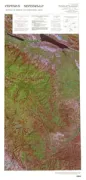
GEOLOGIC MAP OF THE ENNIS QUADRANGLE, WY
Geologic map of the Ennis 30' x 60' quadrangle, Madison and Gallatin Counties, Montana, and Park County, Wyoming
GEOLOGIC MAP MTM 25047&20047 QUADS, MARS
Geologic map of the MTM 25047 and 20047 quadrangles, central Chryse Planitia/Viking 1 Lander site, Mars
GEOLOGIC MAP MCCARTHY D-1 QUADRANGLE, AK
Geologic map of the McCarthy D-1 Quadrangle, Alaska
STELLWAGEN BANK, QUAD 7, MA, MA
Sun-illuminated sea floor topography of Quadrangle 7 in the Stellwagen Bank National Marine Sanctuary off Boston, Massachusetts
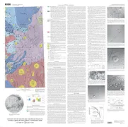
GEOLOGIC MAP PANDROSOS DORSA QUAD VENUS
GEOLOGIC MAP OF THE PANDROSOS DORSA QUADRANGLE (V-5), VENUS
LOWER SILURIAN STRATA,OH,NY,PA, OH
Subsurface correlations and sequence stratigraphic interpretations of lower Silurian strata in the Appalachian Basin of northeast Ohio, southwest New York, and northwest Pennsylvania
BASEMENT MAP OF NORTH AMERICA
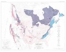
BASEMENT ROCK MAP OF NORTH AMERICA