
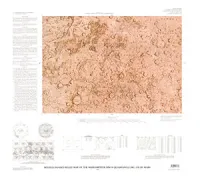
POWDER RIVER BASIN,S/2,SEDIMEN, WY

Geologic map showing thickness of sedimentary rocks from the ground surface to the top of the upper Cretaceous Pierre Shale in the south half of the Powder River Basin, northeastern Wyoming and adjacent areas
LAKE MICHIGAN SOUTHERN-SEDIMEN, MI
Physiography and sediment distribution of Indiana Shoals, southern Lake Michigan
GEOLOGIC OSIRIS APSU SULCI GANYMEDE
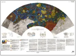
Geologic map of the Osiris (Jg-12) and Apsu Sulci (Jg-13) quadrangles of Ganymede
JAMAICA TOWNSHEND, WINDHAM BEN, VT
Bedrock geologic map of the Jamaica and part of the Townshend quadrangles, Windham and Bennington counties, Vermont
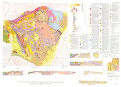
MOUNT ADAMS VOLCANIC FIELD, WA
Geologic map of the Mount Adams volcanic field, Cascade Range of southern Washington
GEOLOGIC PERRINE & NUN SULCI GANYMEDE
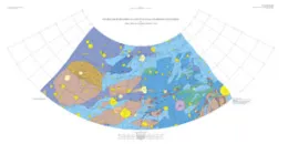
Geologic map of the Perrine (Jg-2) and Nun Sulci (Jg-5) quadrangles of Ganymede
GEOLOGIC MAP MT BARCROFT/PIPER PEAK, NV
Geologic map of late Cenozoic deposits and faults in parts of the Mt. Barcroft, Piper Peak, and Soldier Pass 15' quadrangles, Esmeralda County, Nevada, and Mono County, California
LUNAE PALUS, SHADED RELIEF &CM
Revised shaded relief map and controlled color photomosaic of the Lunae Palus Quadrangle (MC-10) of Mars
LAVINIA PLANITIA REGION VENUS

The Lavinia Planitia region of Venus in four map sheets; 1, Radar image map of the Lavinia Planitia region of Venus; 2, Radar image and shaded relief map of the Lavinia Planitia region of Venus; 3, Altimetric radar image map of the Lavinia Planitia region of Venus; 4, Topographic map of the Lavinia Planitia region of Venus
ARABIA, SHADED RELIEF & CM
Revised shaded relief map and controlled color photomosaic of the Arabia Quadrangle (MC-12) of Mars
MORRILL COUNTY, GEOLOGIC, NE
Geologic map of Morrill County, Nebraska
GEOLOGIC MAP THE ISLAND OF HAWAII, HI
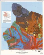
Geologic map of the Island of Hawaii Sheets 1, 2, 3, & Expanatory pamphlet (Reprinted 2009)
GEOL MAP CENTRAL & SOUTH HIGHLAND MTNS
Geologic map and cross sections of the central and southern Highland Mountains, southwestern Montana
RELIEF MARGARITIFER SINUS MC-19 MARS
Revised shaded relief map and controlled color photomosaic of the Margaritifer Sinus Quadrangle (MC-19) of Mars
ST LOUIS, BEDROCK GEOLOGIC, MO
Bedrock geologic map of the St. Louis 30' x 60' Quadrangle, Missouri and Illinois