
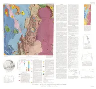
POWDER RIVER BASIN,S/2,CRETACE, WY

Geologic map showing thickness of the upper Cretaceous Pierre Shale in the south half of the Powder River Basin, northeastern Wyoming and adjacent areas
MONTARA MOUNTAIN, GEOLOGIC MAP, CA
Geologic map of the Montara Mountain and San Mateo 7-1/2' quadrangles, San Mateo County, California
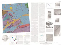
SNOWSTORM MOUNTAINS & VICINITY, NV
Geologic map of the Snowstorm Mountains and vicinity, Elko and Humboldt counties, Nevada
GEOLOGIC HATHOR REGION (JG-15) GANYMEDE
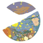
Geologic map of the Hathor region (Jg-15) of Ganymede
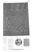
GEOLOGIC MAPS KASEI VALLES REGION MARS
Geologic maps of the MTM 25062 Quadrangle (digital compilation) and the MTM 25067 Quadrangle (manual compilation), Kasei Valles region of Mars
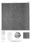
GEOLOGIC MAP MANGALA VALLES REGION MARS
Geologic map of the MTM-15147 Quadrangle, Mangala Valles region of Mars
CONTROLLED PHOTOMOSAIC ORCUS PATERA MARS
Controlled photomosaic of the MTM 20187 Quadrangle, Orcus Patera region of Mars
SIERRITA-MOGOLLON CORRIDOR STU, AZ
Structure contour map on the Martin Formation (Devonian) in the Sierrita-Mogollon Corridor study area
GEOLOGIC MAP OF ALAMAGAN VOLCANO MARIANA
Geologic map of Alamagan Volcano, northern Mariana Islands
CONTROLLED PHOTOMOSAIC ORCUS PATERA MARS
Controlled photomosaic of the MTM 20202 Quadrangle, Orcus Patera region of Mars
OUTER PLANETS, IRREGULAR MOONS
Voyager images of irregularly shaped satellites of the outer planets
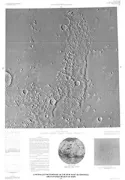
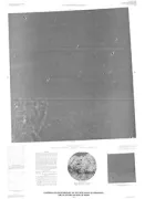
CONTROLLED MOSAIC ACIDALIA PLANITIA MARS
Controlled photomosaic of the MTM 40007 Quadrangle, Acidalia Planitia region of Mars
CONTROLLED MOSAIC GORDII DORSUM MARS
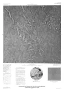
Controlled photomosaic of the MTM 00142 Quadrangle, Gordii Dorsum region of Mars
CONTROLLED MOSAIC GORDII DORSUM MARS
Controlled photomosaic of the MTM 05142 Quadrangle, Gordii Dorsum region of Mars
SAN JOAQUIN VALLEY, GEOLOGIC, CA
Geologic map of the west border of the San Joaquin Valley in the Panoche Creek-Cantua Creek area, Fresno and San Benito counties, California