
CONTROLLED MOSAIC ARGYRE PLANITIA MARS
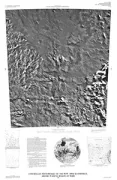
Controlled photomosaic of the MTM 50036 Quadrangle, Argyre Planitia region of Mars
CONTROLLED MOSAIC PAVONIS MONS MARS
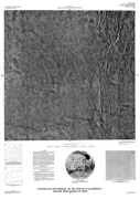
Controlled photomosaic of the MTM 00117 Quadrangle, Pavonis Mons region of Mars
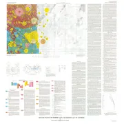
CONTROLLED MOSAIC MA'ADIM VALLIS MARS
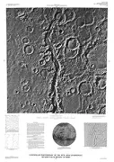
Controlled photomosaic of the MTM 20182 Quadrangle, Ma'Adim Vallis region of Mars
MARINE GEOLOGIC INSULAR GUANICA TO PONCE

Marine geologic map of the Puerto Rico insular shelf Guanica to Ponce area
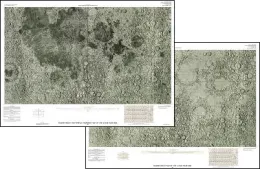
CONTROLLED MOSAIC PLANUM AUSTRALE MARS
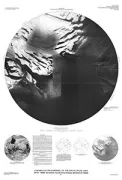
Controlled photomosaic of the south polar area (MTM 90000: revised), Planum Australe region of Mars
GEOLOGIC/STRUCTURE MAP OF RATON QUAD, NM
Geologic and structure-contour map of the Raton 30' x 60' Quadrangle, Colfax and Union counties, New Mexico, and Las Animas County, Colorado
GEOLOGIC MAP OF HILO QUADRANGLE, HI
Geologic map of the Hilo 7 1/2' Quadrangle, island of Hawaii
SHADED RELIEF MARKINGS LUNAR NEAR SIDE
Shaded relief and surface markings map of the Lunar near side
PORT MOLLER/STEPOVAK BAY/SIMEN, AK
Geologic map of Port Moller, Stepovak Bay, and Simeonof Island quadrangles, Alaska Peninsula, Alaska
GEOLOGIC MEMPHIS FACULA QUAD GANYMEDE
Geologic map of the Memphis Facula Quadrangle (Jg-7) of Ganymede
POWDER RIVER BASIN,N/2, GEOL &, MT
Geologic and structure map of the Powder River basin, Southeastern Montana and northeastern Wyoming
RED POCKETS, GEOLOGIC MAP, AZ
Geologic map of the Red Pockets Quadrangle, Mohave County, Arizona
JUMPUP CANYON & BIG SPRINGS, AZ
Geologic map of Jumpup Canyon and Big Springs quadrangles, Mohave and Coconino counties, Arizona
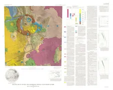
AGE VOLCANIC CENTERS COLORADO & UTAH, CO
Map showing distribution, composition, and age of early and middle Cenozoic volcanic centers in Colorado and Utah
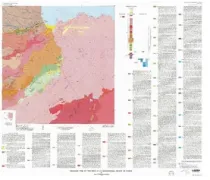
GEOLOGIC MAP MTM-20147 QUAD MANGALA MARS
Geologic map of the MTM -20147 Quadrangle, Mangala Valles Region of Mars