
TOPOGRAPHIC MAP OF MARS
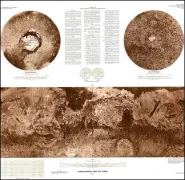
Topographic map of Mars
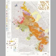
KLAMATH W/2, GEOLOGIC MAP, OR

Geologic map of the west half of the Klamath Falls 1 degree by 2 degrees Quadrangle, south-central Oregon
RHYOLITE RIDGE-LATE CENOZOIC, NV
Geologic map of late Cenozoic deposits and faults in the western part of the Rhyolite Ridge 15' Quadrangle, Esmeralda County, Nevada
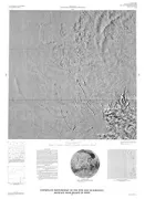
CONTROLLED PHOTOMOSAIC TEMPE FOSSAE MARS
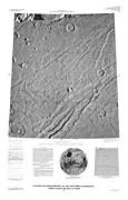
Controlled photomosaic of the MTM 50063 Quadrangle, Tempe Fossae region of Mars
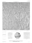
CONTROLLED MOSAIC MAREOTIS/TEMPE MARS
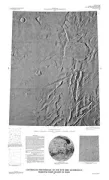
Controlled photomosaic of the MTM 40087 Quadrangle, Mareotis/Tempe Region of Mars
ISLE DEMIERES-SHORELINE CHANGE, LA
Shoreline changes of the Isles Dernieres barrier island arc, Louisiana, from 1853 to 1989
PORTAGE, GEOLOGIC MAP, MT
Geologic map of the Portage Quadrangle, Cascade and Choteau counties, Montana
TUCSON MOUNTAINS CALDERA, GEOL, AZ
Geologic map of the Tucson Mountains Caldera, southern Arizona
WASHAKIE BASIN - OIL SHALE, WY
Correlation and oil-shale assays of measured sections of the LaClede bed of the Laney Member of the Green River Formation in outcrops along the western margins of Washakie Basin, Wyoming, and Sand Wash Basin, Colorado
CONTROLLED MOSAIC ASCREAUS MONS MARS
Controlled photomosaic of the MTM 10107 Quadrangle, Ascreaus Mons region of Mars
CONTROLLED MOSAIC QUAD ARSIA MONS MARS
Controlled photomosaic of the MTM 05127 Quadrangle, Arsia Mons region of Mars
GEOLOGIC MP DODGE RANCH AYRES SPRING, WY
Geologic map and geochronology of the Precambrian and adjacent rocks of the Dodge Ranch-Ayres Spring area, Albany County, Wyoming
FLETCHER PARK-JOHNSON MOUNTAIN, WY
Geologic map, petrochemistry, and geochronology of the Precambrian rocks of the Fletcher Park-Johnson Mountain area, Albany and Platte counties, Wyoming
REESE MOUNTAIN HIGHTOWER SW, WY
Geologic maps and petrochemistry of the Precambrian rocks of the Reese Mountain-Hightower SW and Potato Creek areas, Albany and Platte counties, Wyoming
PETROCHEMSTRY/GEOLOGY BULL CAMP PEAK, WY
Geologic map, petrochemistry, and geochronology of the Precambrian rocks of the Bull Camp Peak Quadrangle, Albany County, Wyoming