
TOPOGRAPHIC MAP AEOLIS NW OF MARS
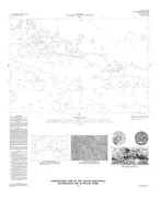
Topographic map of the Aeolis Northwest Quadrangle (MC-23 NW) of Mars
TOPOGRAPHIC MAP SINUS SABAEUS NE MARS
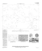
Topographic map of the Sinus Sabaeus Northeast Quadrangle (MC-20 NE) of Mars
MONTANA - DISTURBED BELT, MT

Bedrock geologic map of part of the disturbed belt south and east of Glacier National Park, Montana
POWDER RIVER BASIN,S/2,COAL TH, WY
Geologic map showing total thickness of coal in the south half of the Powder River basin, northeastern Wyoming
ROCKY MOUNTAINS-HEAVY METALS, WY
Composite measured section showing nonopaque heavy minerals in sedimentary rocks of middle Proterozoic to late Tertiary age in the central Rocky Mountains, southwest Wyoming and northwest Colorado
STRICKER 2, GEOLOGIC MAP, ID
Geologic map of the Stricker 2 Quadrangle, Twin Falls and Cassia counties, Idaho
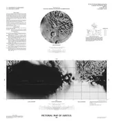
PICTORIAL CONTROL PHOTOMOSAIC ENCELADUS
Pictorial map and controlled photomosaic of Enceladus
PICTORIAL CONTROLLED PHOTOMOSAIC IAPETUS
Pictorial map and controlled photomosaic of Iapetus
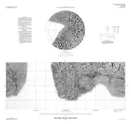
PICTORIAL MAP OF MIMAS
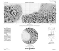
Pictorial map of Mimas
GLENS FALLS-BARIUM IN WATER, NY
Isopleth maps showing above-median concentrations of barium and strontium in stream-sediment concentrate, Glens Falls 1 degree by 2 degrees Quadrangle, New York, Vermont, and New Hampshire
JACOBS WELL & ELBOW CANYON, AZ
Geologic map of the Jacobs Well and southern part of the Elbow Canyon quadrangles, Mohave County, Arizona
MOUNT BANGS, GEOLOGIC MAP, AZ
Geologic map of the Mount Bangs Quadrangle, Mohave County, Arizona
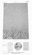
CONTROLLED MOSAIC ARSIA MONS REGION MARS
Controlled photomosaic of the MTM 10122 Quadrangle, Arsia Mons region of Mars
GEOLOGIC MAP GREENVILLE 1X2 QUAD, GA, SC
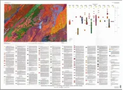
Geologic map of the Greenville 1 degree by 2 degrees Quadrangle, Georgia, South Carolina, and North Carolina
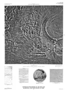
CONTROLLED PHOTOMOSAIC TEMPE FOSSAE MARS
Controlled photomosaic of the MTM 45062 Quadrangle, Tempe Fossae Region of Mars