
ATLAS NORTHERN HEMISPHERE OF VENUS
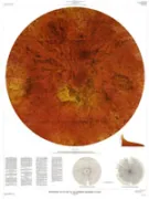
Atlas of Venus 1:15,000,000 topographic series, northern hemisphere
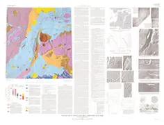
NEVADA TEST SITE, GEOLOGIC MAP, NV

Geologic map of the Nevada Test Site, southern Nevada
BUTTE-MIN RES ASS GOLD/SILVER, MT
Map showing mineral resource assessment for vein and replacement deposits of gold, silver, copper, lead, zinc, manganese, and tungsten in the Butte 1 degree by 2 degrees Quadrangle, Montana
GEOLOGIC MAP OF LERNA REGION (JI-4) IO
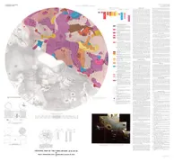
Geologic map of the Lerna region (Ji-4) of Io
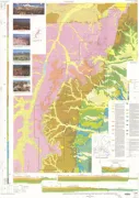
BAYAN OBO AREA, GEOLOGIC MAP
Geologic map of the Bayan Obo area, Inner Mongolia, China
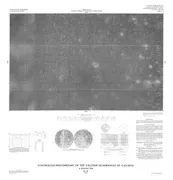
CONTROLLED MOSAIC TYRRHENA PATERA MARS
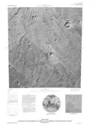
Controlled photomosaic of part of the Tyrrhena Patera region of Mars
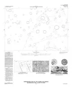
CONTROLLED MOSAIC GLOI QUAD CALLISTO
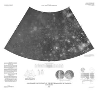
Controlled photomosaic of the Gloi Quadrangle of Callisto
CONTROLLED MOSAIC VALFODR QUAD CALLISTO
Controlled photomosaic of the Valfodr Quadrangle of Callisto
UNCOMPAHGRE UPLIFT NW PART, UT
Geologic map of the northwestern part of the Uncompahgre Uplift, Grand County, Utah, and Mesa County, Colorado, with emphasis on Proterozoic rocks
POWDER RIVER BASIN, S/2, COAL, WY
Geologic map showing the thickness and structure of the Anderson-Wyodak coal bed in the south half of the Powder River basin, northeastern Wyoming
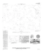
TOPOGRAPHIC MAP ARABIA SW QUAD MARS
Topographic map of the Arabia Southwest Quadrangle (MC-12 SW) of Mars
SALT LAKE CITY - WASATCH FAULT, UT
Surficial geologic map of the Salt Lake City segment and parts of adjacent segments of the Wasatch fault zone, Davis, Salt Lake, and Utah counties, Utah
BRYCE CANYON NATIONAL PARK,GEO, UT
Geologic map of Bryce Canyon National Park and vicinity, southwestern Utah
TOPOGRAPHIC MAP MARE TYRRHENUM NE MARS
Topographic map of the Mare Tyrrhenum Northeast Quadrangle (MC-22 NE) of Mars
GEOLOGIC SCIENCE STUDY AREA 2 MARS
Geologic map of science study area 2, north Kasei Valles, Mars (MTM 25072 Quadrangle)