
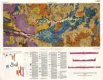
BLOOM CREEK, GEOLOGIC MAP, MT

Geologic map of the Bloom Creek Quadrangle, Powder River County, Montana
COLORADO METALLOGENIC MAP, CO
Metallogenic map of stratabound exhalative and related occurrences in Colorado
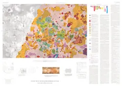
MOOREHEAD, GEOLOGIC MAP, WY
Geologic map of the Moorhead Quadrangle, Powder River County, Montana, and Campbell County, Wyoming
ANCHORAGE - ORE RELATED MINERA, AK
Mineralogical maps showing distribution of ore-related minerals in the nonmagnetic, heavy-mineral-concentrate fraction of stream sediment from the Anchorage 1 degree x 3 degrees Quadrangle, southern Alaska
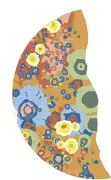
GEOLOGIC MAP OF THE RUWA PATERA QUAD IO
Geologic map of the Ruwa Patera Quadrangle of Io (Ji2)
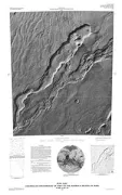
MOUNT EDGECUMBE VOLCANIC FIELD, AK
Geologic map of the Mount Edgecumbe volcanic field, Kruzof Island, southeastern Alaska
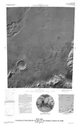
GLASS MOUNTAIN, GEOLOGIC MAP, CA
Geologic map of Glass Mountain, Mono County, California
ROLLA, GEOLOGIC MAP, MO
Geologic map of the Rolla 1 degree by 2 degrees Quadrangle, Missouri
GEOLOGIC MAP VALLES MARINERIS E&W MARS
Geologic Map of the Valles Marineris Region, Mars
CASCADE RANGE, UP ECOCENE-HOLO, WA
Geologic map of upper Eocene to Holocene volcanic and related rocks in the Cascade Range, Washington
FORT HALL INDIAN RESERV,E PART, ID
Geologic map of the eastern part of the Fort Hall Indian Reservation, Bannock, Bingham, and Caribou counties, Idaho
GEOLOGIC MAP BACH REGION OF MERCURY
Geologic map of the Bach region of Mercury
TONOPAH SPRING, SURFICIAL DEP, NV
Geologic map of the surficial deposits of the Topopah Spring Quadrangle, Nye County, Nevada
CONTROLLED MOSAIC HADRIACA REGION MARS
Controlled photomosaic of part of the Hadriaca region of Mars, MTM - 35267
CONTROLLED MOSAIC HADRIACA REGION MARS
Controlled photomosaic of part of the Hadriaca region of Mars, MTM - 35262