
RICE LAKE-GEOL OF PRCAMBRIAN R, WI

Geologic map of Precambrian rocks of Rice Lake 1 degree by 2 degrees Quadrangle, northern Wisconsin
CONTROLLED MOSAIC NILOSYRTIS MENSAE MARS
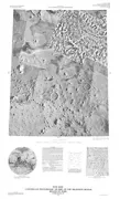
Controlled photomosaic of part of the Nilosyrtis Mensae region of Mars, MTM 40292
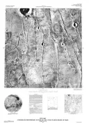
CONTROLLED PHOTOMOSAIC MAJA VALLES MARS
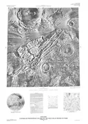
Controlled photomosaic of part of the Maja Valles region of Mars
BUFFALO, BEDROCK GEOLOGIC MAP, WY
Bedrock geologic map and coal sections in the Buffalo 30' x 60' Quadrangle, Johnson and Campbell counties, Wyoming
BLISS/HAGERMAN/TUTTLE, ID
Geologic map and profiles of the north wall of the Snake River Canyon, Bliss, Hagerman, and Tuttle quadrangles, Idaho
LEPPY PEAK & ADJ AREAS, GEOL, NV
Geologic map of Leppy Peak Quadrangle, Elko County, Nevada, and Toole County, Utah
PHOENIX - LANDSAT & SPOT IMAGE, AZ
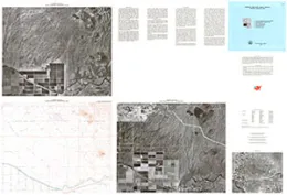
Landsat and SPOT image display, Phoenix, Arizona area
GEOLOGIC MAP OF SALT LAKE CITY QUAD, UT
Geologic map of the Salt Lake City 30' x 60' Quadrangle, north-central Utah, and Uinta County, Wyoming
PASADENA VALLEY & TICESKA, ID
Geologic map and profiles of the north wall of the Snake River Canyon, Pasadena Valley and Ticeska quadrangles, Idaho
FLORENCE & GEORGETOWN, SC
Aeroradiometric map and geologic interpretation of part of the Florence and Georgetown 1 degree by 2 degrees Quadrangles, South Carolina
CONTROLLED PHOTOMOSAIC LUNAE PLANUM MARS
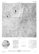
Controlled photomosaic of part of the Lunae Planum region of Mars, MTM 10067
CONTROLLED PHOTOMOSAIC LUNAE PLANUM MARS
Controlled photomosaic of part of the Lunae Planum region of Mars, MTM 15067
COAL STRATIGRAPHY POWDER RIVER BASIN, WY
Cross sections showing coal stratigraphy of the southeastern Powder River basin, Wyoming
POWDER RIVER BASIN,CENTR,X-SEC, MT
Cross section showing the reconstructed stratigraphic framework of Paleocene rocks and coal beds in the central Powder River basin from Decker to Bear Skull Mountain, Montana
INTERNATIONAL FALLS, BEDROCK, MN
Bedrock geologic map of the International Falls 1 degree by 2 degrees Quadrangle, Minnesota, United States and Ontario, Canada