
PINE GROVE-BLAWN MTN AREA, UT

Geologic map of the Pine Grove-Blawn Mountain area, Beaver County, Utah
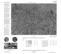
SHADED RELIEF PHOENICIS LACUS NW MARS
Shaded relief map of the Phoenicis Lacus Northwest Quadrangle of Mars
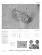
PRELIMINARY PICTORIAL MAP OF TETHYS
Preliminary pictorial map of Tethys
SHADED RELIEF PELORUS LINEA EUROPA
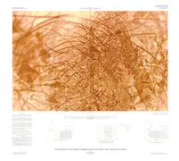
Shaded relief and surface markings of the Pelorus Linea region of Europa (sheet 1); airbrush base for the Pelorus Linea region of Europa (sheet 2)
HIGH-RESOLUTION CONTROL PHOTOMOSAIC IO
High resolution controlled photomosaics of Io
GLACIER NP - MOUNT JACKSON ARE, MT
Map showing distribution of moraines and extent of glaciers from the mid-19th century to 1979 in the Mount Jackson area, Glacier National Park, Montana
CONTROLLED PHOTOMOSAIC CEBRENIA NW MARS
Controlled photomosaic of the Cebrenia Northwest Quadrangle of Mars
WALLACE-COPPER SILVER DEPOSITS, MT
Resource appraisal map for stratabound copper-silver deposits in the Wallace 1 degree by 2 degrees Quadrangle, Montana and Idaho
WALLACE - PRECIOUS METAL VEIN, MT
Resource appraisal map for mesothermal base- and precious-metal veins in the Wallace 1 degree by 2 degrees Quadrangle, Montana and Idaho
VIKING LANDER 2 PHOTOMOSAIC MORNING SCEN
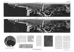
Viking Lander 2 rectified photomosaic (morning scene, camera 2)
US WESTERN VOLCANIC CENTERS, US
Map showing distribution, composition, and age of late Cenozoic volcanic centers in the western conterminous United States
VERMILION DISTRICT-WESTERN, MN
Geologic map of Archean rocks, western Vermilion District, northern Minnesota
BEAVER, UT
Geologic map of the Beaver quadrangle, Beaver and Piute Counties, Utah
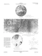
SHADED RELIEF MAP AEOLIS QUADRANGLE MARS
Shaded relief map of the Aeolis Quadrangle of Mars
FAIRFAX COUNTY - WATER QUALITY, VA
The relation of water quality to geology and land use changes in Fairfax County and vicinity, Virginia