
GEOLOGIC MAP VICTORIA QUADRANGLE MERCURY
Geologic map of the Victoria Quadrangle of Mercury
BOUGUER GRAVITY MAP PUEBLO 1X2, CO

Bouguer gravity map of the Pueblo 1 degree by 2 degrees Quadrangle, south-central Colorado
GEOLOGIC SECTIONS ACROSS COLORADO, CO
Geologic sections across Colorado
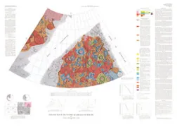
PUEBLO - GEOCHEMICAL WEST 2/3, CO
Trace-element geochemical maps of the western three-quarters of the Pueblo 1 degree x 2 degrees Quadrangle, south-central Colorado
MOBILE - QUATERNARY, AL
Quaternary geologic map of the Mobile 4 degrees x 6 degrees quadrangle, United States
QUATERNARY GEOLOGIC MAP VICKSBURG 4X6 QU
Quaternary geologic map of the Vicksburg 4 degrees x 6 degrees quadrangle, United States
QUATERNARY GEOLOGIC OF THE DAKOTAS, SD
Quaternary geologic map of the Dakotas 4 degrees x 6 degrees quadrangle, United States
QUATERNARY GEOLOGIC MAP BOSTON QUAD, MA
Quaternary geologic map of the Boston 4 degrees x 6 degrees quadrangle, United States and Canada
QUATERNARY GEOLOGIC LAKE SUPERIOR 4X6
Quaternary geologic map of the Lake Superior 4 degrees x 6 degrees quadrangle, United States and Canada
GEOLOGIC MAP OF THE LAKE OF THE WOODS
Quaternary geologic map of the Lake of the Woods 4 degrees x 6 degrees quadrangle, United States and Canada
FREEL PEAK, CA
Geologic map of the Freel Peak 15-minute Quadrangle, California and Nevada
TUSHAR MTNS & ADJOINING AREAS, UT
Distribution of anomalous trace elements in the nonmagnetic fraction of heavy-mineral concentrates of stream sediments, shown on a geologic base map of the Tushar Mountains and adjoining areas, Marysvale volcanic field, Utah
SHERIDAN - ENG GEOLOGIC, WY
Engineering geologic map of the Sheridan Quadrangle, Sheridan County, Wyoming
CONTROLLED MOSAIC HELLAS NE QUAD MARS
Controlled photomosaic of the Hellas Northeast Quadrangle of Mars
ROCHELLE HILLS-FISSION TRACK, WY
Map showing fission-track ages of clinker in the Rochelle Hills, southern Campbell and Weston counties, Wyoming