
SILVER CITY-MINERAL RES ASSESS, NM

Maps showing mineral resource assessment of the Silver City 1 degree by 2 degrees Quadrangle, New Mexico and Arizona
MINERAL RESOURCES CULPEPER BASIN, VA
Map showing mineral resources of the Culpeper Basin, Virginia and Maryland availability and planning for future needs
CULPEPER BASIN - GROUND WATER, VA
Chemical quality of ground water in the Culpeper Basin, Virginia and Maryland
ASHEBORO AND ADJACENT AREAS, NC
Geologic map of the Asheboro, North Carolina, and adjacent areas
RELIEF/SURFACE MARKING LUNAR POLAR REGN
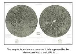
Map showing relief and surface markings of the lunar polar regions
US - DIGITAL TERRAINE MAP, US
Digital terrain map of the United States
ALTIMETRIC & SHADED RELIEF MAP OF VENUS
Altimetric and shaded relief map of Venus
CONTROLLED PHOTOMOSAIC AMAZONIS SW MARS
Controlled photomosaic of the Amazonis Southwest Quadrangle of Mars
CONTROLLED PHOTOMOSAIC ERIDANIA NW MARS
Controlled photomosaic of the Eridania Northwest Quadrangle of Mars
IRON RIVER - BEDROCK GEOLOGIC, MI
Bedrock geologic map of the Iron River 1 degree by 2 degrees Quadrangle, Michigan and Wisconsin
IRON RIVER - CHROMIUM DISTRIBU, WI
Chromium distribution in B-horizon soils, Iron River 1 degree by 2 degrees Quadrangle, Michigan and Wisconsin
IRON RIVER - SILVER DISTRIBUTI, MI
Silver distribution in B-horizon soils, Iron River 1 degree by 2 degrees Quadrangle
MOCCASIN MOUNTAINS, MT
Geologic map and discussion of selected mineral resources of the North and South Moccasin Mountains, Fergus County, Montana
VIKING LANDER 1 PHOTOMOSAIC EVENING MARS
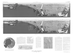
Viking Lander 1 rectified photomosaics evening scene; camera 1, Mars
GEOLOGIC MUDDY & NORTH BLACK MTNS, NV
Geologic map, tectonic map and structure sections of the Muddy and northern Black Mountains, Clark County, Nevada