
SAN MATEO COUNTY SLOPE MAP, CA

Slope map of San Mateo County, California
SAN MATEO COUNTY - DEBRIS FLOW, CA
Map of debris-flow probability, San Mateo County, California
SAN MATEO COUNTY - VEGETATION, CA
Map showing vegetation in San Mateo County, California
MARINE GEOLOGIC ISLA CAJA DE MUERTOS, PR
Marine geologic map of the Puerto Rico insular shelf, Isla Caja de Muertos area
LAVA FLOWS SE DIACRIA QUADRANGLE MARS
Map showing lava flows in the southeast part of the Diacria Quadrangle of Mars
LAVA FLOWS SE PHOENICIS LACUS QUAD MARS
Map showing lava flows in the southeast part of the Phoenicis Lacus Quadrangle of Mars
CORPUS CHRISTI - CONTINENTAL T, TX
Map showing structure of the continental terrace in the corpus Christi 1 degree by 2 degrees Quadrangle, Texas
BEEVILLE - PALEOGEOGRAPHY, TX
Map showing paleogeography of the continental shelf during the low stand of sea level, Wisconsin glacial epoch, Beeville 1 degree by 2 degrees Quadrangle, Texas
BEEVILLE - CONTINENTAL TERRACE, TX
Map showing structure of the continental terrace in the Beeville 1 degree by 2 degrees Quadrangle, Texas
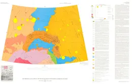
GRAND JUNCTION 1 X 2, CO
Surficial geologic map of the Grand Junction 1 degree by 2 degrees Quadrangle, Colorado and Utah
SHADED RELIEF MARGARIFITER SINUS MARS
Shaded relief map of the Margaritifer Sinus Quadrangle of Mars
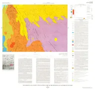
REDMOND - RECONNAISSANCE GEOLO, UT
Reconnaissance geologic map of the Redmond Quadrangle, Sanpete and Sevier counties, Utah
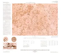
CONTROL MOSAIC LUNAE PALUS NE QUAD MARS
Controlled photomosaic of the Lunae Palus Northeast quadrangle of Mars
WYOMING, SE, STRATIG/POTENTIOM, WY
Generalized fence diagram showing stratigraphy and potentiometric surface of the Tertiary formations in southeastern Wyoming and an adjacent part of Colorado
SILVER CITY-GEOCHEMICAL INTERP, NM
Geochemical interpretive and summary maps, Silver City 1 degree by 2 degrees Quadrangle, New Mexico and Arizona