
STERLING - LAND CLASSIFICATION, CO

Leasable mineral and waterpower land classification map of the Sterling 1 degree x 2 degrees quadrangle, Colorado, Nebraska, and Kansas : lands withdrawn, classified and prospectively valuable for leasable minerals; occurrences of other selected minerals; and lands withdrawn or classified for waterpower and reservoir sites
DEER TRAIL MTN, ALUNITE RIDGE, UT
Geologic map of the Deer Trail Mountain-Alunite Ridge mining area, west-central Utah
GEOLOGIC MAP KUIPER QUADRANGLE MERCURY
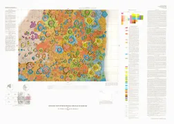
Geologic map of the Kuiper Quadrangle of Mercury
PRELIMINARY PICTORIAL MAP OF IO
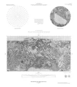
Preliminary pictorial map of Io
THERMAL MATURITY, NV
Maps for assessing thermal maturity (conodont color alteration index maps) in Ordovician through Triassic rocks in Nevada and Utah and adjacent parts of Idaho and California
BOUGUER GRAVITY MAP CHARLOTTE, NC
Simple Bouguer gravity map of the Charlotte 1 degree by 2 degrees Quadrangle, North Carolina and South Carolina
CHARLOTTE - AREOMAGNETIC, NC
Aeromagnetic map of the Charlotte 1 degree by 2 degrees Quadrangle, North Carolina and South Carolina
CHARLOTTE - URANIUM/THORIUM, NC
Mineral resource potential for uranium and thorium in the Charlotte 1 degree by 2 degrees Quadrangle, North Carolina and South Carolina
PORT ISABEL - TRACE METAL, TX
Map showing trace-metal content and texture of surficial bottom sediments in the Port Isabel 1 degree by 2 degrees Quadrangle, Texas
PORT ISABEL- WATER CIRCULATION, TX
Map showing water circulation and rates of sedimentation in the Port Isabel 1 degree by 2 degrees Quadrangle, Texas
PORT ISABEL - SHALLOW SEDIMENT, TX
Map showing nature of shallow subsurface sediments and biogeology in the Port Isabel 1 degree by 2 degrees Quadrangle, Texas
PORT ISABEL - FAULTING, TX
Map showing post-Wisconsin sedimentation patterns and faulting in the Port Isabel 1 degree by 2 degrees Quadrangle, Texas
SAN MATEO COUNTY - SEDIMENT, CA
Map showing direction and amount of bedding dip of sedimentary rocks in San Mateo County, California
SAN MATEO COUNTY SLOPE STABIL, CA
Map showing slope stability during earthquakes in San Mateo County, California
SAN MATEO COUNTY - LIQUEFACTIO, CA
Map showing liquefaction susceptibility of San Mateo County, California