
CONTROLLED PHOTOMOSAIC COPRATES SW MARS
Controlled photomosaic of the Coprates Southwest Quadrangle of Mars
CONTROLLED PHOTOMOSAIC COPRATES SE MARS
Controlled photomosaic of the Coprates Southeast Quadrangle of Mars
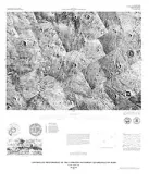
CONTROLLED PHOTOMOSAIC MEMNONIA NW MARS
Controlled photomosaic of the Memnonia Northwest Quadrangle of Mars
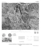
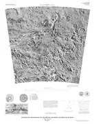
CONTROLLED PHOTOMOSAIC ARGYRE NE MARS
Controlled photomosaic of the Argyre Northeast Quadrangle of Mars
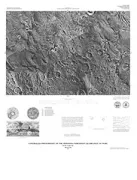
CONTROLLED PHOTOMOSAIC ARGYRE NW MARS
Controlled photomosaic of the Argyre Northwest Quadrangle of Mars
RENO JUNCTION/ANTELOPE CK COAL, WY

Structure contour and isopach maps of the Wyodak-Anderson coal bed in the Reno Junction-Antelope Creek area, Campbell and Converse counties, Wyoming
MERCURY - GEOLOGIC & TECTONIC, NV
Geologic and tectonic maps of the Mercury Quadrangle, Nye and Clark counties, Nevada
BLACK MOUNTAIN, GEOLOGIC MAP, CO
Geologic map of the Black Mountain Quadrangle, Fremont and Park counties, Colorado
RENO JUNCTION ANTELOPE CK COAL, WY
Lower Tertiary coal bed distribution and coal resources of the Reno Junction-Antelope Creek area Campbell, Converse, Niobrara, and Weston counties, Wyoming
MOUNDS - RECONN GEOLOGIC, UT
Reconnaissance geologic map of the Mounds Quadrangle, Carbon and Emery counties, Utah
PORT TOWNSEND - COASTAL EROSIO, WA
Map showing coastal erosion, sediment supply, and longshore transport in the Port Townsend 30- by 60-minute quadrangle, Puget Sound Region, Washington
VERNAL - SURFICIAL GEOLOGIC, CO
Surficial geologic map of the Vernal 1 degree x 2 degrees quadrangle, Colorado and Utah
CONTROLLED MOSAIC PHOENICIS LACUS MARS
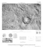
Controlled photomosaic of the Phoenicis Lacus Northwest Quadrangle of Mars
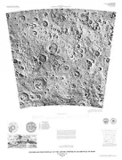
RELIEF/SURFACE MARKING OF LUNAR FAR SIDE
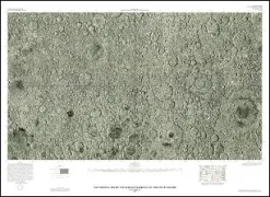
Map showing relief and surface markings on the lunar far side
COLOR LANDSAT PHOTOMOSAIC OF NEVADA, NV
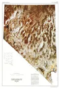
Synthetic natural color Landsat photomosaic of Nevada