
CONNECTICUT VALLEY URBAN AREA, CT

Map showing textures of unconsolidated materials, Connecticut Valley urban area, central New England
CONNECTICUT VALLEY URBAN AREA, CT
Map showing ranges in elevation of land surface above mean sea level, Connecticut Valley urban area central New England
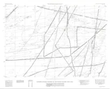
WHITE RIVER - CHANNEL MIGRATIO, UT
Channel migration of the White River in the eastern Uinta Basin, Utah and Colorado
SHADED RELIEF MARE ORIENTALE AREA MOON
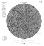
Shaded relief map of the Mare Orientale area of the Moon
GEOLOGIC CRATER SECTION HALEAKALA NP, HI
Geologic map of the Crater section of Haleakala National Park, Maui, Hawaii
COEUR D'ALENE DISTRICT-BARIUM, ID
General distribution of barium and mercury in the Coeur d'Alene district, Idaho and Montana
COEUR D'ALENE DISTRICT-SILVER, ID
General distribution of antimony and silver in rocks and soils of the Coeur d'Alene district, Idaho and Montana
COEUR D'ALENE DISTICT-ARSENIC, ID
General distribution of arsenic in rocks and soils and sulfur in rocks in the Coeur d'Alene district, Idaho and Montana
PACIFIC OCEAN NE - BATHYMETRIC
BATHYMETRIC AND NODULE ASSESSMENT MAP NORTHEAST EQUATORIAL PACIFIC OCEAN 1402 N LAT
PACIFIC OCEAN - EQUATOR BATHY
Bathymetric map of the northeast Equatorial Pacific Ocean
PACIFIC OCEAN NE - BATHYMETRIC
BATHYMETRIC AND NODULE ASSESSMENT MAP NORTHEAST EQUATORIAL PACIFIC OCEAN 1203 N LAT
GREAT FALLS-LEASABLE LAND MINE, MT
Leasable mineral and waterpower land classification map of the Great Falls 1 x 2 Quadrangle, Montana lands withdrawn, classified and prospectively valuable for leasable minerals; occurrences of other selected minerals; and lands withdrawn or classified for waterpower and reservoir sites
SALT LAKE CTY-LEASABLE LAND MI, UT
Leasable mineral and waterpower land classification map of the Salt Lake City 1 x 2 Quadrangle, Utah and Wyoming
GEOLOGIC MAP AMENTHES QUADRANGLE MARS
Geologic map of the Amenthes Quadrangle of Mars
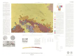
PARK RANGE - NORTHERNMOST, CO
Geologic map of the northernmost Park Range and the southernmost Sierra Madre, Jackson and Routt counties, Colorado