
FREMONT & OMAHA (PART OF), NE

Bedrock geologic map showing thickness of overlying Quaternary deposits, Fremont Quadrangle and part of Omaha Quadrangle, Nebraska
GEOLOGIC MAP AVELLA AND STEUBENVILLE, PA
Geologic map of the Avella quadrangle and part of the Steubenville East Quadrangle, Washington County, Pennsylvania
TENNESSEE, W'ERN, CRETACEOUS &, TN
Geologic map showing upper Cretaceous, Paleocene, and lower and middle Eocene units and distribution of younger fluvial deposits in western Tennessee
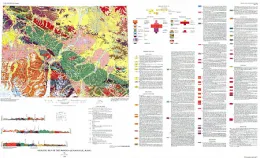
APPALACHIAN BASIN, PALEOZOIC, US
Oil and gas data from Paleozoic rocks in the Appalachian Basin; maps for assessing hydrocarbon potential and thermal maturity (conodont color alteration isograds and overburden isopachs)
STRAWBERRY VALLEY - WEST HALF, UT
Geologic map of the west half of the Strawberry Valley Quadrangle, Utah
MONTGOMERY COUNTY - MIN RES, MD
Map showing mineral resources of Montgomery County, Maryland
MONTGOMERY COUNTY - BEDROCK, MD
Bedrock map of Montgomery County, Maryland
NABESNA, GEOLOGIC MAP, AK
Geologic map of the Nabesna Quadrangle, Alaska
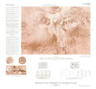
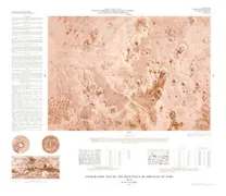
SHADED RELIEF ERYTHRAEUM REGION OF MARS
Shaded relief map of the Erythraeum region of Mars
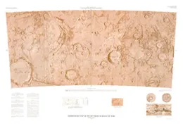
SHADED RELIEF OF BACH AREA OF MERCURY
Shaded relief map of the Bach area of Mercury (Australia Albedo Province)
SOUTH FORK, GEOLOGIC MAP, CO
Geologic map of the South Fork area, eastern San Juan Mountains, southwestern Colorado
GROVE CENTER/SHAWNEETOWN, KY
Map showing bedrock topography and subcrop of selected beds beneath alluvial deposits of the Grove Center Quadrangle and part of the Shawneetown Quadrangle, Kentucky-Illinois
TOPO MAP PHOENICUS LACUS QUADRANGLE MARS
Topographic map of the Phoenicis Lacus Quadrangle of Mars
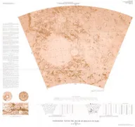
TOPOGRAPHIC OXIA PALUS QUADRANGLE MARS
Topographic map of the Oxia Palus Quadrangle of Mars
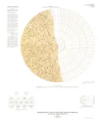
TOPOGRAPHIC MAP ARGYRE QUADRANGLE MARS
Topographic map of the Argyre Quadrangle of Mars