
DEPTH WATER TABLE 1976-7 DENVER AREA, CO

Depth to the water table (1976-1977) in the Greater Denver area, Front Range urban corridor, Colorado
FLOOD: COLORADO SPRINGS/CASTLE ROCK, CO
Map showing flood-prone areas, Colorado Springs-Castle Rock area, Front Range Urban Corridor, Colorado
COLO SPGS/CASTLE ROCK - LAKES, CO
LAKES IN THE COLORADO SPRINGS - CASTLE ROCK AREA FRONT RANGE URBAN CORRIDOR COLORADO
CENSUS TRACTS 1970 WASHINGTON, DC
Census tracts, 1970, Washington urban area, District of Columbia, Maryland, and Virginia
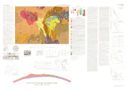
GEOLOGIC MAP PONCE QUAD PUERTO RICO, PR
Geologic map of the Ponce Quadrangle, Puerto Rico
WEST FRANKLIN/CABORN/MT VERNON, KY
Map showing bedrock topography of parts of the West Franklin, Caborn, and Mount Vernon quadrangles, Henderson and Union counties, Kentucky
INDONESIA, BATHYMETRIC MAP
Bathymetric map of the Indonesian region
INDONESIA, SEDIMENTARY BASIN
Map of sedimentary basins of the Indonesian region
MCCLEDE MOUNTAIN, MO, CU, ZN, NM
Map showing anomalous distribution of molybdenum, copper, and zinc in stream-sediment concentrates from the Sierra Cuchillo-Animas uplifts and adjacent areas, southwestern New Mexico
NAVAJO - HOPI INDIAN RESERVATION, AZ
Availability of ground water for irrigation, municipal, or industrial use in the Navajo and Hopi Indian Reservations, Arizona, New Mexico, and Utah
SURFICIAL GEOLOGIC MAP JUNEAU URBAN AREA
Surficial geologic map of the Juneau urban area and vicinity, Alaska
FAIRBANKS D-2 NW, AK
Geologic map of the Fairbanks D-2 NW Quadrangle, Alaska
CENTENNIAL FAULT, GEOLOGY OF A, MT
Geology of a strip along the Centennial fault, southwestern Montana and adjacent Idaho
GEOLOGIC MAP PHOENICIS LACUS QUAD MARS
Geologic map of the Phoenicis Locus Quadrangle of Mars
COSTA RICA, CENTRAL, GEOLOGIC
Reconnaissance geologic map and cross sections of central Costa Rica