
HARTFORD NORTH, DEPTH TO BEDRK, CT

Depth to bedrock, Hartford North Quadrangle, Connecticut
HARTFORD NORTH, LANDFORMS, CT
Landforms, Hartford North Quadrangle, Connecticut
HARTFORD NORTH, CLAY THICKNESS, CT
Thickness of principal clay unit, Hartford North Quadrangle, Connecticut
HARTFORD NORTH, DEPTH TO WATER, CT
Depth to water table, Hartford North Quadrangle, Connecticut
ASPEN - PERMEABILITY OF ROCKS, CO
Map showing relative permeability of rocks and surficial deposits of the Aspen Quadrangle, Pitkin County, Colorado
ASPEN - BEDROCK/SURF DEPOSITS, CO
Map showing types of bedrock and surficial deposits in the Aspen Quadrangle, Pitkin County, Colorado
GEOLOGIC MAP MACROBIUS QUAD THE MOON
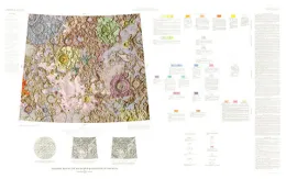
Geologic map of the Macrobius Quadrangle of the Moon
MORRISON - PERMEABILITY, CO
Map showing inferred relative permeability of geologic materials in the Morrison Quadrangle, Jefferson County, Colorado
STILLWATER COMPLEX, GEOLOGIC, MT
Geologic map of the Stillwater complex, Montana
TUNGSTEN - DENSITY OF HOUSES, CO
Map showing density of dwelling units in the Tungsten Quadrangle, Boulder, Gilpin, and Jefferson counties, Colorado
GEOLOGIC BOUGUER GRAVITY REVEILLE, NV
Geologic and Bouguer gravity map of the Reveille Quadrangle, Nye County, Nevada
GEOLOGIC MAP PURBACH QUAD THE MOON
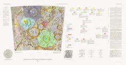
Geologic map of the Purbach Quadrangle of the Moon
GEOLOGIC MAP OUTER SHUMAGIN ISLANDS, AK
Geologic and structural map of part of the outer Shumagin Islands, southwestern Alaska
TAMAQUA, ANTHRACITE-BEARING, PA
Geologic map of anthracite-bearing rocks in the Tamaqua Quadrangle, Carbon and Schuylkill counties, Pennsylvania
GEOLOGIC STRUCTURAL SANAK ISLANDS, AK
Geologic and structural map of the Sanak Islands, southwestern Alaska