
GEOLOGIC MAP GURABO PUERTO RICO, PR

Geologic map of the Gurabo Quadrangle, Puerto Rico
GEOLOGIC CENTRAL LA PLATA , PR
Geologic map of the Central La Plata Quadrangle, Puerto Rico
HATCH POINT 15', SE/4, GEOLOG, UT
Geologic map of the southeast quarter of the Hatch Point Quadrangle, San Juan County, Utah
HATCH POINT 15', SW/4, GEOLOG, UT
Geologic map of the southwest quarter of the Hatch Point Quadrangle, San Juan County, Utah
MARSHALL, GEOLOGIC MAP, AK
Geologic map of the Marshall Quadrangle, western Alaska
ORWIGSBURG, ANTHRACIT-BEARING, PA
Geologic map of anthracite-bearing rocks in the north part of the Orwigsburg Quadrangle, Schuylkill County, Pennsylvania
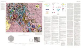
GEOLOGIC MAP HOMMEL QUADRANGLE THE MOON
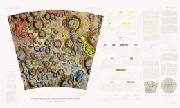
Geologic map of the Hommel Quadrangle of the Moon
GENERALIZED TECTONIC MAP NORTH AMERICA
Generalized tectonic map of North America IMAP 688 By: P. B. King and Gertrude J. Edmonston https://doi.org/10.3133/i688
GEOLOGIC MAP MAUROLYCUS QUADRANGLE MOON
Geologic map of the Maurolycus Quadrangle of the Moon
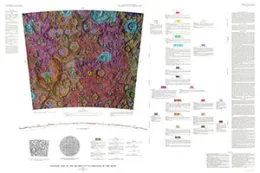
GEOLOGIC MAP RHEITA QUADRANGLE OF MOON
Geologic map of the Rheita Quadrangle of the Moon
CEDAREDGE - RECONN GEOLOGIC, CO
Reconnaissance geologic map of the Cedaredge area, Delta County, Colorado
GEOLOGIC FRA MAURO REGION MOON APOLLO
Geologic map of the Fra Mauro region of the Moon Apollo 14 pre-mission maps
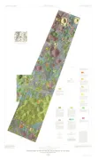
PRELIMINARY GEOLOGIC MAP NEMO DISTRI, SD
Preliminary geologic map of the Nemo district, Black Hills, South Dakota
GEOLOGIC MAP YELLOWSTONE NAT'L PARK, WY

Geologic map of Yellowstone National Park
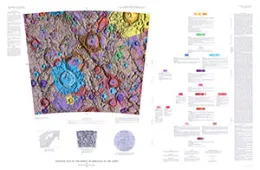
GEOLOGIC MAP COLOMBO QUADRANGLE MOON
Geologic map of the Colombo Quadrangle of the Moon