
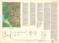
SALINA, VEGETATION MAP, UT

Vegetation map of the Salina Quadrangle, Utah
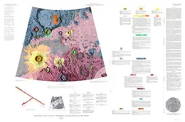
GEOLOGIC MAP SABINE DM REGION THE MOON
(RLC-9) Geologic map of the Sabine DM region of the moon
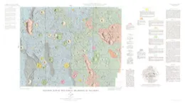
GEOLOGIC MAP J HERSCHEL QUAD THE MOON
(LAC-11) Geologic map of the J. Herschel quadrangle of the moon
CUMMINS MOUNTAIN, GEOLOGIC MAP, CA
Geologic map of the Cummings Mountain Quadrangle, Kern County, California
YAKATAGA DISTRICT, GEOLOGIC, AK
Geologic map of the Yakataga District, Gulf of Alaska Tertiary Province, Alaska
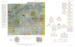
GEOLOGIC MAP SABINE D REGION SITE MOON
(ORB II-6 (100)) Geologic map of the Sabine D region of the moon, Lunar Orbiter site II P-6, southwestern Mare Tranquillitatis including Apollo landing site 2
GEOLOGIC APOLLO LANDING SITES 3 & 3R
Geologic map of Apollo landing sites 3 and 3R (Part of Oppolzer A region, Sinus Medii)
GEOLOGIC MAP OROCOVIS, PR
Geologic map of the Orocovis Quadrangle, Puerto Rico
MONTEZUMA STOCK - SOIL ANALYS, CO
Maps showing soil analyses of interest for prospecting the Montezuma stock, Summit County, Colorado
HUCKLEBERRY MOUNTAIN, GEOLOGIC, WY
Surficial geologic map of the Huckleberry Mountain Quadrangle, Yellowstone National Park and adjoining area, Wyoming
MOUNBT HOLMES, GEOLOGIC, WY
Surficial geologic map of the Mount Holmes Quadrangle and parts of the Teepee Creek, Crown Butte and Miner quadrangles, Yellowstone National Park, Wyoming and Montana
EAGLE PEAK - GEOLOGIC, WY
Surficial geologic map of the Eagle Peak Quadrangle, Yellowstone National Park and adjoining area, Wyoming
NORRIS JUNCTION - SURF GEOLOG, WY
Surficial geologic map of the Norris Junction Quadrangle, Yellowstone National Park, Wyoming
ABIATHAR PEAK - SURF GEOLOGIC, WY
Surficial geologic map of the Abiathar Peak and parts of adjacent quadrangles, Yellowstone National Park, Wyoming and Montana
PATTERSON RIDGE, GEOLOGIC MAP, WA
Geologic map of the proposed Paterson Ridge Pumped-Storage Reservoir, south-central Washington