
CAPITOL PEAK NW, GEOLOGIC MAP, NM

Geologic map of the Capitol Peak NW quadrangle, Socorro County, New Mexico
US, 37TH DEGREE, CRUSTAL X/SEC, US
Geologic and crustal cross section of the United States along the 37th parallel a contribution to the Upper Mantle project
FLORIDA, MAP SHOW REL OF LAND, FL
MAP SHOWING RELATION OF LAND AND SUBMARINE TOPOGRAPHY, NOVA SCOTIA TO FLORIDA
MENOMINEE IRON DIST & VIC, GEO, WI
Map showing Precambrian geology of the Menominee iron-bearing district and vicinity, Michigan and Wisconsin
KWIGUK & BLACK, GEOLOGIC MAP, AK
Geologic map of the Kwiguk and Black quadrangles, western Alaska
LAVIC, GEOLOGIC MAP OF, CA
Geologic map of the Lavic quadrangle, San Bernardino County, California
ULTRAMAFIC INTRUSIVE MAFIC, AL
Map showing distribution of ultramafic and intrusive mafic rocks from northern New Jersey to eastern Alabama
CRESCENT, E/2, RECONN GEOLOGIC, OR
Reconnaissance geologic map of the east half of the Crescent quadrangle, Lake, Deschutes, and Crook Counties, Oregon
MARE HUMORUM REGION, GEOLOGIC, MOON
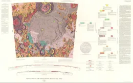
(LAC-93) Geologic map of the Mare Humorum region of the moon
IRON SPRINGS, RECONN GEOLOGY, AZ
Reconnaissance geologic map of the Iron Springs quadrangle, Yavapai County, Arizona
JULIUS CAESAR, GEOLOGIC MAP OF, THE MOON
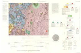
(LAC-60) Geologic map of the Julius Caesar quadrangle of the moon
GEOLOGIC MAP OF JAYUYA PUERTO RICO, PR
Geologic map of the Jayuya quadrangle, Puerto Rico
COPPER RIVER BASIN,SW'ERN, ENG, AK
Engineering geologic map of the southeastern Copper River basin, Alaska
SELECUS, GEOLOGIC MAP, MOON
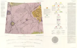
(LAC-38) Geologic map of the Seleucus quadrangle of the moon
US, WEST CENTRAL, GRAV & BATHY, US
Transcontinental geophysical survey (35-39 N.) gravity and bathymetric map from the coast of California to 133 W. longitude