
GEOLOGY, STRUCTURE, URANIUM MOAB, CO, UT

Geology, structure, and uranium deposits of the Moab quadrangle, Colorado and Utah
SPRING CREEK, GEOLOGIC MAP OF, MT
Geologic map of the Spring Creek quadrangle, Valley County, Montana
HAY CREEK, GEOLOGIC MAP OF, MT
Geologic map of the Hay Creek quadrangle, Roosevelt County, Montana
HOGAN-4, PRELIM GEOLOGIC MAP, MT
Preliminary geologic map and sections of the Hogan 4 Southeast quadrangle, Lewis and Clark County, Montana
COWBOY PASS NE, GEOLOGIC & X/S, UT
Geologic map and section of the Cowboy Pass NE quadrangle, Confusion Range, Millard County, Utah
SNAKE RIVER, RECON GEOL MAP OF, ID
Reconnaissance geologic map of west-central Snake River plain, Idaho
INDIAN WELL, GEOLOGIC MAP OF, TX
Geologic map of the Indian Wells quadrangle, Terrell and Brewster Counties, Texas
BEDROCK TOPOGRAPHY CENTRAL MESABI RANGE
Bedrock topography of the eastern and central Mesabi Range, northeastern Minnesota
TORRANCE STATION 4 NE, GEOLOG, NM
Geologic map and sections of the Torrance Station 4 NE quadrangle, Lincoln County, New Mexico
SOUTH CAROLINA, CRYSTAL ROCK, SC
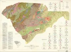
Geologic map of the crystalline rocks of South Carolina
TEPEE CREEK, PRELIM GEOLOGIC, MT
Preliminary geologic map of the Tepee Creek quadrangle, Montana-Wyoming
ALASKA, EXTENT OF GLACIATIONS, AK
Map showing extent of glaciations in Alaska
BANNACK-GRAYLING AREA, GEOLOG, MT
Geologic map of the Bannack-Grayling area, Beaverhead County, Montana
GEOLOGIC MAP PIERRE SHALE LOVELAND, CO
Geologic and biostratigraphic map of the Pierre shale between Jarre Creek and Loveland, Colorado
DUNCAN/CANADOR PEAK, GEOLOGIC, AZ
Geologic map of the Duncan and Canador Peak quadrangles, Arizona and New Mexico