
PARIA SE, PHOTOGEOLOGIC, UT

Photogeologic map of the Paria SE quadrangle, Kane County, Utah, and Coconino County, Arizona
COCKSCOMB SE, PHOTOGEOLOGIC, UT
Photogeologic map of the Cockscomb SE quadrangle, Kane County, Utah
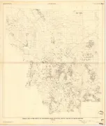
COACH CREEK SE, PHOTOGEOLOGIC, UT
Photogeologic map of the Coach Creek SE quadrangle, Grand County, Utah, and Mesa County, Colorado
BETHEL, GEOLOGY OF, AK
Geology of the Bethel quadrangle, Alaska
MELOZITNA, RECONN GEOLOGY OF, AK
Reconnaissance geologic map of the Melozitna quadrangle, Alaska
RUSSIAN MISSION, GEOLOGY OF, AK
Geology of the Russian Mission quadrangle, Alaska
HAGEMEISTER ISLAND, GEOLOGIC, AK
Geologic map of the Hagemeister Island quadrangle, Alaska
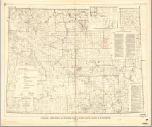
CROOKS CREEK SW, PHOTOGEOLOGIC, WY
Photogeologic map of the Crooks Creek SW quadrangle, Fremont and Sweetwater Counties, Wyoming
WYOMING, INGEOUS/METAMORP W/UR, WY
Geologic map of the igneous and metamorphic rocks of Wyoming showing location of uranium deposits
MONTANA, W/2 INGE/METAMOR W/UR, MT
Geologic map of the igneous and metamorphic rocks of Montana showing location of uranium deposits
MONTANA, E/2 IGNE/METAMOR W/UR, MT
GEOLOGIC MAP OF THE IGNEOUS AND MEOMORPHIC ROCKS OF MONTANA SHOWING LOCATION OF URANIUM
CLIMAX STOCK & VIC, PRELIM GEO, NV
Preliminary geologic map of the Climax stock and vicinity, Nye County, Nevada
FAIRBANKS D-3, GEOLOGIC MAP OF, AK
Geologic map and section of the Fairbanks D-3 quadrangle, Alaska
EASTERN CHUGACH MTS,RECONN/TRA, AK
Reconnaissance traverse across the Eastern Chugach Mountains, Alaska
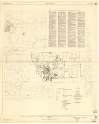
STORM HILL, GEOLOGIC MAP OF, WY
Geologic map of the Storm Hill quadrangle, Crook County, Wyoming