
SNAKE RIVER PLAIN - GEOHYDROLO, ID

Geohydrologic framework of the Snake River Plain, Idaho and eastern Oregon
OZARK PLATEAUS PROVINCE, MO
Major geohydrologic units in and adjacent to the Ozark Plateaus province, Missouri, Arkansas, Kansas and Oklahoma-Western Interior Plains confining system
UNITED STATES WEST - RECONN, US
Reconnaissance study of the thickness of the unsaturated zone in the western conterminous United States
SAN JUAN STRUCTURAL BASIN, NM
Hydrogeology of the Menefee Formation in the San Juan structural basin, New Mexico, Colorado, Arizona and Utah
KANSAS - GEOHYDROLOGIC SYSTEM, KS
Geohydrologic systems in Kansas physical framework of the lower aquifer unit in the western interior plains aquifer system
CENTRAL OKLAHOMA AQUIFER, OK
Hydrogeologic maps of the central Oklahoma aquifer, Oklahoma
WASHINGTON - MT RAINIER FLOOD, WA
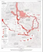
Debris flow, debris avalanche and flood hazards at and downstream from Mount Rainier, Washington
KANSAS - GEOHYDROLOGIC SYSTEM, KS
Geohydrologic systems in Kansas, geohydrology of the lower aquifer unit in the western interior plains aquifer system
GROUND WATER ATLAS OF US, SEGMENT 5, AR
Ground water atlas of the United States: Segment 5, Arkansas, Louisiana, Mississippi
GROUND WATER ATLAS OF US, SEGMENT 7, ID
Ground water atlas of the United States: Segment 7, Idaho, Oregon, Washington
GROUND WATER ATLAS OF US, SEGMENT 4, OK
Ground water atlas of the United States: Segment 4, Oklahoma, Texas
UPPER MISS RIVER FLOOD JUNE 93, IA
Delineation of flooding within the upper Mississippi River Basin-flood of June 18 through August 4, 1993, in Des Moines and vicinity, Iowa
STRUCTURE OF BEDROCK AQUIFERS, CO
Structure, outcrop, and subcrop of the bedrock aquifers along the western margin of the Denver Basin, Colorado
SHALLOW AQUIFERS FT COLLINS-LOVELAND, CO
Geohydrology of the shallow aquifers in the Fort Collins-Loveland area, Colorado
BLACK HILLS, SD POTENTIOMETRI, SD
Potentiometric surface of the Inyan Kara Aquifer in the Black Hills area, South Dakota